 Filter: Categories of Wisconsin Historical Images
Filter: FORMAT_DIMENSIONS of 8.5 x 11 inches
Filter: Subject of maps
Filter: Categories of Wisconsin Historical Images
Filter: FORMAT_DIMENSIONS of 8.5 x 11 inches
Filter: Subject of maps
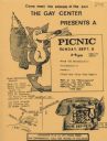
| Date: | 1979 |
|---|---|
| Description: | Poster for picnic presented by the Gay Center at Vilas Park. Includes an image of a fox and telephone. |
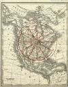
| Date: | 1890 |
|---|---|
| Description: | Rand, McNally map of North America enhanced to show Superior as the center of a wheel. The image was used on the back of stationery from City Improvement C... |

| Date: | 1936 |
|---|---|
| Description: | Cover of an advertising catalog for McCormick-Deering combines (harvester-threshers). Text on the cover reads: "Combines built for West Coast Growers: McCo... |
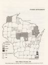
| Date: | 1920 |
|---|---|
| Description: | Map of Wisconsin showing native Polish populations by county. |
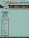
| Date: | 1947 |
|---|---|
| Description: | Letterhead of the All Wisconsin Sports Show, presented by the Madison Business Association, with an outline map of the state and a star marking the locatio... |

| Date: | 04 15 1915 |
|---|---|
| Description: | A sketch of Little Lake Butte des Morts and the surrounding area, including Neenah and Menasha. |
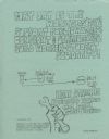
| Date: | 1974 |
|---|---|
| Description: | Flyer advertising a May Day rally in support of public workers to be held at Library Mall on the University of Wisconsin-Madison campus. Local public worke... |

| Date: | 1937 |
|---|---|
| Description: | Map showing territory controlled by the Finches, a family of bandits who terrorized south central Wisconsin in the years prior to the Civil War. The map in... |

| Date: | 01 13 1937 |
|---|---|
| Description: | Sketch map of Township 7 North, Range 9 East, created for the Land Economic Inventory (Bordner Survey). The map shows Picnic Point and the Lake Mendota sho... |
If you didn't find the material you searched for, our Library Reference Staff can help.
Call our reference desk at 608-264-6535 or email us at: