 Filter: Categories of Wisconsin Historical Images
Filter: FORMAT_DIMENSIONS of 8.5 x 11 inches
Filter: Type of Map or Atlas
Filter: Categories of Wisconsin Historical Images
Filter: FORMAT_DIMENSIONS of 8.5 x 11 inches
Filter: Type of Map or Atlas
| Date: | 1935 |
|---|---|
| Description: | Map of a portion of Central Wisconsin with areas zoned for reforestation. The area is divided into two sites which are shaded in purple and red. |

| Date: | 1935 |
|---|---|
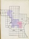
| Description: | Map of Juneau County showing area zoned for reforestation shaded in red. |
| Date: | 1965 |
|---|---|
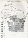
| Description: | Map of Wisconsin showing counties shaded according to when Dutch Elm Disease was first found in the county. |

| Date: | 1906 |
|---|---|
| Description: | A diagram of Township No 37 Range No 8 in Sawyer County. |

| Date: | 1906 |
|---|---|
| Description: | A list of owners of land in Township No 37 Range No 8 in Sawyer County. |
If you didn't find the material you searched for, our Library Reference Staff can help.
Call our reference desk at 608-264-6535 or email us at: