Filter: Categories of Wisconsin Historical Images
Filter: FORMAT_DIMENSIONS of 7.5 x 9.5 inches
Filter: Subject of rivers
Filter: Categories of Wisconsin Historical Images
Filter: FORMAT_DIMENSIONS of 7.5 x 9.5 inches
Filter: Subject of rivers
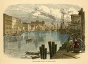
| Date: | 1874 |
|---|---|
| Description: | Milwaukee River in the downtown area, looking south from the west side of the Wisconsin Avenue Bridge. |

| Date: | 1867 |
|---|---|
| Description: | Drawn map showing planned development of Cornell, including a couple of schools, Oakwood cemetery, the public square, and several bridges and dams. |
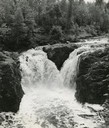
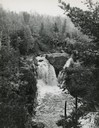
| Date: | 1937 |
|---|---|
| Description: | Elevated view of the waterfall where the Bad River tumbles over the Keweenawan Trap Ledge. |
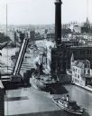
| Date: | 1938 |
|---|---|
| Description: | Elevated view of a tugboat pulling a lake steamer on the Milwaukee River under an open drawbridge near the Electric Company. |
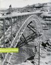
| Date: | 1959 |
|---|---|
| Description: | An International truck sits on a bridge spanning Glen Canyon and the Colorado River. |
If you didn't find the material you searched for, our Library Reference Staff can help.
Call our reference desk at 608-264-6535 or email us at: