 Filter: Categories of Wisconsin Historical Images
Filter: FORMAT_DIMENSIONS of 7 x 5 inches
Filter: Categories of Wisconsin Historical Images
Filter: FORMAT_DIMENSIONS of 7 x 5 inches

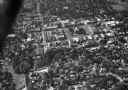
| Date: | 1930 |
|---|---|
| Description: | Aerial view of the Wisconsin State Capitol, the surrounding businesses, and Lake Monona. |
| Date: | 1934 |
|---|---|
| Description: | Aerial view of the Jones dairy farm, Fort Atkinson, in winter. The Rock River is in the background. |

| Date: | 1930 |
|---|---|
| Description: | Aerial view of the Wisconsin State Capitol and the surrounding businesses. |

| Date: | 10 1928 |
|---|---|
| Description: | Aerial view of Mount Horeb, including the central business district. |

| Date: | 1930 |
|---|---|
| Description: | Aerial view of the Wisconsin State Capitol and the surrounding businesses. |

| Date: | 11 1928 |
|---|---|
| Description: | Aerial view of Stoughton, including the central business district, residential areas, the Yahara River, and the surrounding countryside. |

| Date: | 1930 |
|---|---|
| Description: | Aerial view of the city with horizon in the far distance. Includes the Wisconsin State Capitol, businesses, Lake Monona, and the surrounding neighborhoods. |

| Date: | 11 1928 |
|---|---|
| Description: | Aerial view residential areas of Windsor and the surrounding countryside. |

| Date: | 11 1928 |
|---|---|
| Description: | Aerial view of Black Earth residential area and the surrounding countryside. |

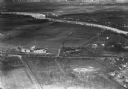
| Date: | 1930 |
|---|---|
| Description: | Aerial view of the town, including the central business district. |
| Date: | 11 1928 |
|---|---|
| Description: | Aerial view of Oregon, including the central business disctrict, residential areas, schools, and the surrounding countryside. |

| Date: | 1930 |
|---|---|
| Description: | Aerial view of the University of Wisconsin-Madison campus including Camp Randall Stadium, the Wisconsin State Capitol, and both Lake Mendota and Lake Monon... |
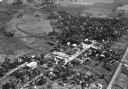
| Date: | 1930 |
|---|---|
| Description: | Aerial view of the town and the surrounding countryside. |

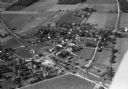
| Date: | 1930 |
|---|---|
| Description: | Aerial view of the town and the surrounding countryside. |

| Date: | 11 1928 |
|---|---|
| Description: | Aerial view of Cross Plains, including residences and the surrounding countryside. |
| Date: | 1935 |
|---|---|
| Description: | Aerial view of the French Battery Company facility, East Washington Avenue, and Winnebago Street at the Union Corners intersection. |
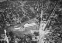
| Date: | 1930 |
|---|---|
| Description: | Aerial view of the town including the County Courthouse and the surrounding buildings. |
| Date: | |
|---|---|
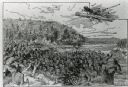
| Description: | An illustration titled "The Battle of the Brule" based on an 1840's battle between the Ojibwe and Dakota Sioux over territory in the Ashland, Wisconsin are... |

| Date: | 06 13 1919 |
|---|---|
| Description: | Former Wisconsin State Senator David G. James, Republican from Richland Center (1908-1912) and the father of suffragist Ada James. The photograph was likel... |
If you didn't find the material you searched for, our Library Reference Staff can help.
Call our reference desk at 608-264-6535 or email us at:
