 Filter: Categories of Wisconsin Historical Images
Filter: FORMAT_DIMENSIONS of 7 x 5 inches
Filter: Year of 1900-1999
Filter: Categories of Wisconsin Historical Images
Filter: FORMAT_DIMENSIONS of 7 x 5 inches
Filter: Year of 1900-1999
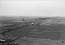
| Date: | 1930 |
|---|---|
| Description: | Aerial view of the town and the surrounding countryside. |

| Date: | 1930 |
|---|---|
| Description: | Aerial view of the town and the surrounding countryside. |

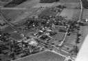
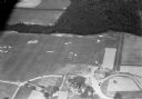
| Date: | 11 1928 |
|---|---|
| Description: | Aerial view of Cross Plains, including residences and the surrounding countryside. |
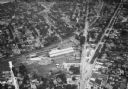
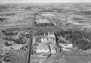
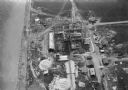
| Date: | 1935 |
|---|---|
| Description: | Aerial view of the French Battery Company facility, East Washington Avenue, and Winnebago Street at the Union Corners intersection. |
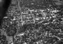
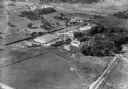
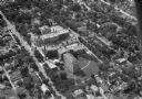
| Date: | 1930 |
|---|---|
| Description: | Aerial view of the town including the County Courthouse and the surrounding buildings. |

| Date: | 06 13 1919 |
|---|---|
| Description: | Former Wisconsin State Senator David G. James, Republican from Richland Center (1908-1912) and the father of suffragist Ada James. The photograph was likel... |
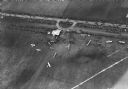
| Date: | 10 06 1928 |
|---|---|
| Description: | Aerial view of the Janesville airport during air races including airplanes in the air, the landing field, and airport structures. |
| Date: | 1932 |
|---|---|
| Description: | Aerial view of the Oscar Mayer meat packing plant, looking north, with the surrounding rural countryside. |
| Date: | 1930 |
|---|---|
| Description: | Aerial view of airplane races at the Janesville airport, including airplanes on the landing field, airport structures, cars parked around the airport, and ... |
| Date: | 1932 |
|---|---|
| Description: | Aerial view of Oscar Mayer Meat Packing Plant and the surrounding countryside. |

| Date: | 1930 |
|---|---|
| Description: | Aerial view of Tenney Park, including the lagoon, residences surrounding the park, and the shoreline of Lake Mendota on bottom left. |

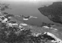
| Date: | 1930 |
|---|---|
| Description: | Aerial view of Wisconsin Dells including the Wisconsin River and the dam and generating power plant. |
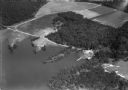
| Date: | 1930 |
|---|---|
| Description: | Aerial view of Lake Delton, the Wisconsin River, and the surrounding countryside. |
| Date: | 1930 |
|---|---|
| Description: | Aerial view of the construction of the Wisconsin Power and Light Company power plant on the shore of Lake Michigan. |
| Date: | 1930 |
|---|---|
| Description: | Aerial view of Lake Delton and shoreline including resort areas. |

| Date: | 1930 |
|---|---|
| Description: | Aerial view of Hoyt Park including the surrounding neighborhoods. Resurrection Cemetery can be seen at the upper right of the image. |
| Date: | 1930 |
|---|---|
| Description: | Aerial view of the Lake Delview Hotel, the golf course, and the surrounding countryside. |
| Date: | 1930 |
|---|---|
| Description: | Aerial view of Madison General Hospital (currently Meriter Hospital), located on South Park Street, and the surrounding residential neighborhoods. |

| Date: | 1930 |
|---|---|
| Description: | Aerial view of the University of Wisconsin-Madison Arboretum including a portion of Lake Wingra and surrounding residential neighborhoods. |

| Date: | 1930 |
|---|---|
| Description: | Aerial view of near west side, including West High School, the Forest Products Laboratory, Lake Mendota, and Picnic Point. |
If you didn't find the material you searched for, our Library Reference Staff can help.
Call our reference desk at 608-264-6535 or email us at: