 Filter: Categories of Wisconsin Historical Images
Filter: FORMAT_DIMENSIONS of 7 x 5 inches
Filter: Year of 1900-1999
Filter: Categories of Wisconsin Historical Images
Filter: FORMAT_DIMENSIONS of 7 x 5 inches
Filter: Year of 1900-1999
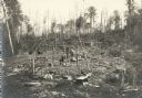
| Date: | 1912 |
|---|---|
| Description: | Vilas County, Ricing camp, Rice Creek. Lac Du Flambeau area. |
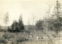
| Date: | 1912 |
|---|---|
| Description: | Vilas County, Ricing camp, Rice Creek. Lac Du Flambeau area. |
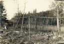
| Date: | 1912 |
|---|---|
| Description: | Vilas County, Ricing camp, Rice Creek. Lac Du Flambeau area. |
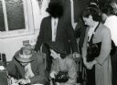
| Date: | 08 05 1942 |
|---|---|
| Description: | Women are booked for prostitution by state agents at the Iron County jail after vice raids at Hurley-area taverns on a Tuesday night. |

| Date: | 1907 |
|---|---|
| Description: | View in winter from Bascom Hill on the University of Wisconsin-Madison campus of the Wisconsin State Capitol (the fourth State Capitol, the third in Madiso... |
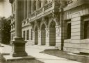
| Date: | 1910 |
|---|---|
| Description: | Front entrance of the State Historical Society of Wisconsin. Awnings are on the windows of the first and second floors. |
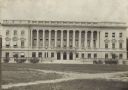
| Date: | 1910 |
|---|---|
| Description: | Exterior of the State Historical Society of Wisconsin from across Library Mall with awnings visible on the first and second floor. |
| Date: | 1930 |
|---|---|
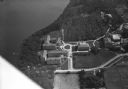
| Description: | Aerial view of Turville Point and Turville farm, Lake Monona. |
| Date: | 10 1928 |
|---|---|
| Description: | Aerial view of DeForest including residences and the surrounding countryside. |
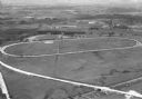
| Date: | 1930 |
|---|---|
| Description: | Aerial view of the Dane County fairgrounds, including several buildings and a track. |
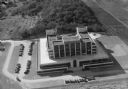
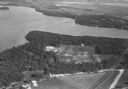
| Date: | 1930 |
|---|---|
| Description: | Aerial view of the Forest Products Laboratory, 1 Gifford Pinchot Drive. |

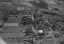
| Date: | 11 1928 |
|---|---|
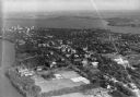
| Description: | Aerial view of Verona including businesses, houses, and the surrounding farm land. |
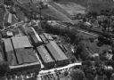
| Date: | 1930 |
|---|---|
| Description: | Aerial view of the Highway Trailer plant at Edgerton. |
| Date: | 1930 |
|---|---|
| Description: | Aerial view of a portion of the University of Wisconsin-Madison campus and the shoreline of Lake Mendota. |
| Date: | 1930 |
|---|---|
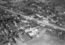
| Description: | Aerial view of the town, including business, houses, and railroad tracks cutting through the town. |
| Date: | 1930 |
|---|---|
| Description: | Aerial view looking southeast, towards the city, including the Wisconsin State Capitol, the central business district, the Capitol Square, both Lake Mendot... |
| Date: | 1930 |
|---|---|
| Description: | Aerial view of the University of Wisconsin-Madison, lakeshore dormitories, Adams Hall and Tripp Hall, also known as Van Hise Dormitories. Buildings include... |
| Date: | 11 1928 |
|---|---|
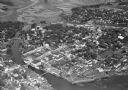
| Description: | Aerial view of Stoughton including the central business district, the Yahara River, and the surrounding countryside. |
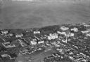
| Date: | 1930 |
|---|---|
| Description: | Aerial view of the Isthmus and the city of Madison including the downtown business district, the Wisconsin State Capitol, both Lake Mendota and Lake Monona... |

| Date: | 1930 |
|---|---|
| Description: | Aerial view of the University of Wisconsin-Madison campus, the State Historical Society of Wisconsin building, Lake Mendota, residential areas and the surr... |
If you didn't find the material you searched for, our Library Reference Staff can help.
Call our reference desk at 608-264-6535 or email us at: