 Filter: Categories of Wisconsin Historical Images
Filter: FORMAT_DIMENSIONS of 7 x 5 inches
Filter: Year of 1900-1999
Filter: Year of 1920-1929
Filter: County of Dane
Filter: Categories of Wisconsin Historical Images
Filter: FORMAT_DIMENSIONS of 7 x 5 inches
Filter: Year of 1900-1999
Filter: Year of 1920-1929
Filter: County of Dane
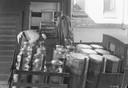
| Date: | 1922 |
|---|---|
| Description: | Two men deliver milk in cans to a creamery from the back of a milk truck. |
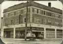
| Date: | 1925 |
|---|---|
| Description: | View from street of new Rennebohm Drug Store #1 at 1357 University Avenue at the corner of Randall Avenue, shortly after its construction. |
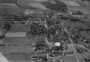
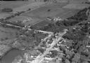
| Date: | 10 1928 |
|---|---|
| Description: | Aerial view of DeForest including residences and the surrounding countryside. |

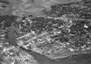
| Date: | 11 1928 |
|---|---|
| Description: | Aerial view of Verona including businesses, houses, and the surrounding farm land. |
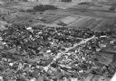
| Date: | 11 1928 |
|---|---|
| Description: | Aerial view of Stoughton including the central business district, the Yahara River, and the surrounding countryside. |
| Date: | 10 1928 |
|---|---|
| Description: | Aerial view of Belleville, including the central business disctrict and the surrounding countryside. |

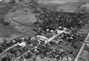
| Date: | 10 1928 |
|---|---|
| Description: | Aerial view of Sun Prairie, including the central business district, residences, and the surrounding countryside stretching to the horizon. |
| Date: | 10 1928 |
|---|---|
| Description: | Aerial view of Sun Prairie, including the central business district, residences, and the surrounding countryside. |

| Date: | 10 1928 |
|---|---|
| Description: | Aerial view of Mount Horeb, including the central business district. |

| Date: | 11 1928 |
|---|---|
| Description: | Aerial view of Stoughton, including the central business district, residential areas, the Yahara River, and the surrounding countryside. |

| Date: | 11 1928 |
|---|---|
| Description: | Aerial view residential areas of Windsor and the surrounding countryside. |

| Date: | 11 1928 |
|---|---|
| Description: | Aerial view of Black Earth residential area and the surrounding countryside. |
| Date: | 11 1928 |
|---|---|
| Description: | Aerial view of Oregon, including the central business disctrict, residential areas, schools, and the surrounding countryside. |

| Date: | 11 1928 |
|---|---|
| Description: | Aerial view of Cross Plains, including residences and the surrounding countryside. |
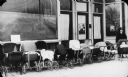
| Date: | 1921 |
|---|---|
| Description: | A mother and infant in a baby carriage pose at the end of a row of wicker baby carriages in front of what is probably the Neighborhood House. |
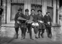
| Date: | 1920 |
|---|---|
| Description: | Reginald Jackson, Jr., of Madison, holding the toy airplane, and a group of friends, all of whom are wearing short pants, sitting on the windowsill in fron... |

| Date: | 1928 |
|---|---|
| Description: | Crowd seated on the lawn of Agriculture Hall on the University of Wisconsin-Madison for a ceremony honoring S.M. Babcock, inventor of the butter test. |
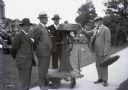
| Date: | 06 09 1928 |
|---|---|
| Description: | S.M. Babcock, on the right, and his original milk butterfat tester at an honorary ceremony. |

| Date: | 1929 |
|---|---|
| Description: | View from water of the Hydraulic Engineering Building on the University of Wisconsin-Madison campus. The building is located on the edge of Lake Mendota an... |
If you didn't find the material you searched for, our Library Reference Staff can help.
Call our reference desk at 608-264-6535 or email us at:
