 Filter: Categories of Wisconsin Historical Images
Filter: FORMAT_DIMENSIONS of 7 x 5 inches
Filter: Subject of trees
Filter: Categories of Wisconsin Historical Images
Filter: FORMAT_DIMENSIONS of 7 x 5 inches
Filter: Subject of trees
| Date: | |
|---|---|
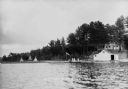
| Description: | People on the shore of East Lake (now called Lake Tahkodah) by the Gifford residence, with tipis in the distance. |
| Date: | |
|---|---|
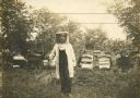
| Description: | George Hodges of Belmont, New York, in protective beekeeper clothing. He was a warden and a beekeeper for a number of years. His wife had died ten years ... |

| Date: | |
|---|---|
| Description: | A man and woman hold up slates of honey comb covered in bees. |
| Date: | 1912 |
|---|---|
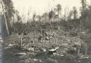
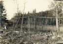
| Description: | Vilas County, Ricing camp, Rice Creek. Lac Du Flambeau area. |
| Date: | 1912 |
|---|---|
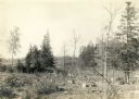
| Description: | Vilas County, Ricing camp, Rice Creek. Lac Du Flambeau area. |
| Date: | 1912 |
|---|---|
| Description: | Vilas County, Ricing camp, Rice Creek. Lac Du Flambeau area. |
| Date: | 1887 |
|---|---|
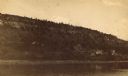
| Description: | View over Mississippi River of town on shoreline with bluff in the background. |
| Date: | |
|---|---|
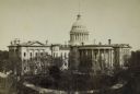
| Description: | Elevated view of the Wisconsin State Capitol. The north and south wings were added in 1882-1884. The trees in the park are not yet full of leaves and did n... |

| Date: | 1907 |
|---|---|
| Description: | View in winter from Bascom Hill on the University of Wisconsin-Madison campus of the Wisconsin State Capitol (the fourth State Capitol, the third in Madiso... |
| Date: | 1910 |
|---|---|
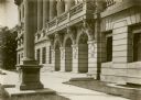
| Description: | Front entrance of the State Historical Society of Wisconsin. Awnings are on the windows of the first and second floors. |

| Date: | 11 1928 |
|---|---|
| Description: | Aerial view of Verona including businesses, houses, and the surrounding farm land. |

| Date: | 10 1928 |
|---|---|
| Description: | Aerial view of Sun Prairie, including the central business district, residences, and the surrounding countryside stretching to the horizon. |

| Date: | 11 1928 |
|---|---|
| Description: | Aerial view of Stoughton, including the central business district, residential areas, the Yahara River, and the surrounding countryside. |

| Date: | 11 1928 |
|---|---|
| Description: | Aerial view residential areas of Windsor and the surrounding countryside. |

| Date: | 11 1928 |
|---|---|
| Description: | Aerial view of Black Earth residential area and the surrounding countryside. |

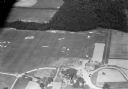
| Date: | 11 1928 |
|---|---|
| Description: | Aerial view of Cross Plains, including residences and the surrounding countryside. |

| Date: | 1930 |
|---|---|
| Description: | Aerial view of Tenney Park, including the lagoon, residences surrounding the park, and the shoreline of Lake Mendota on bottom left. |
| Date: | 1930 |
|---|---|
| Description: | Aerial view of the Lake Delview Hotel, the golf course, and the surrounding countryside. |
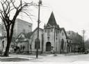
| Date: | 1918 |
|---|---|
| Description: | The First Baptist Church, 201 North Carroll Street. |
If you didn't find the material you searched for, our Library Reference Staff can help.
Call our reference desk at 608-264-6535 or email us at:
