 Filter: Categories of Wisconsin Historical Images
Filter: FORMAT_DIMENSIONS of 7 x 5 inches
Filter: Subject of neighborhoods
Filter: Categories of Wisconsin Historical Images
Filter: FORMAT_DIMENSIONS of 7 x 5 inches
Filter: Subject of neighborhoods
| Date: | 1906 |
|---|---|
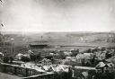
| Description: | Elevated view of Camp Randall Field from the top of Bascom Hall, with University Heights in the background. A crowd is in the stands at the stadium, and a ... |
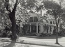
| Date: | 1900 |
|---|---|
| Description: | View from intersection towards a residence on 4th and Green Street. The large house shows many Italianate architectural details, including ornate eaves bra... |
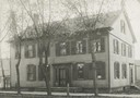
| Date: | 1914 |
|---|---|
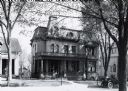
| Description: | John J. Suhr residence at 121 Langdon Street, designed by City Engineer and architect Captain John Nadar. Built in 1886 for immigrant John J. Suhr, Sr. (18... |
| Date: | 1901 |
|---|---|
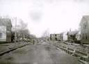
| Description: | View down East Mifflin Street looking north near Blair Street. Men are working on road construction. |

| Date: | 1915 |
|---|---|
| Description: | An abandoned pool room at 912 Williamson Street. |
| Date: | 1912 |
|---|---|
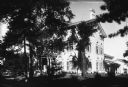
| Description: | Front view of the Burlington house in spring. House built on later site of the Jones house. |
| Date: | 1912 |
|---|---|
| Description: | View from streets towards the entrance to W.A. Fulton's home. |
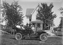
| Date: | |
|---|---|
| Description: | Home of Tina Dahl Bertrand. Lewis Dahl at the wheel of an automobile. Walter and mother second and third from right in back seat. Bertrands on porch. |

| Date: | 1914 |
|---|---|
| Description: | The Blied Apartments at 141 West Gilman Street. |
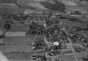
| Date: | 10 1928 |
|---|---|
| Description: | Aerial view of DeForest including residences and the surrounding countryside. |

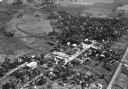
| Date: | 11 1928 |
|---|---|
| Description: | Aerial view of Verona including businesses, houses, and the surrounding farm land. |
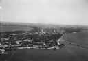
| Date: | 1930 |
|---|---|
| Description: | Aerial view of the Isthmus and the city of Madison including the downtown business district, the Wisconsin State Capitol, both Lake Mendota and Lake Monona... |

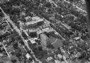
| Date: | 1930 |
|---|---|
| Description: | Aerial view of the University of Wisconsin-Madison campus, the State Historical Society of Wisconsin building, Lake Mendota, residential areas and the surr... |

| Date: | 1930 |
|---|---|
| Description: | Aerial view of the city with horizon in the far distance. Includes the Wisconsin State Capitol, businesses, Lake Monona, and the surrounding neighborhoods. |

| Date: | 11 1928 |
|---|---|
| Description: | Aerial view of Black Earth residential area and the surrounding countryside. |
| Date: | 11 1928 |
|---|---|
| Description: | Aerial view of Oregon, including the central business disctrict, residential areas, schools, and the surrounding countryside. |

| Date: | 1930 |
|---|---|
| Description: | Aerial view of Tenney Park, including the lagoon, residences surrounding the park, and the shoreline of Lake Mendota on bottom left. |

| Date: | 1930 |
|---|---|
| Description: | Aerial view of Hoyt Park including the surrounding neighborhoods. Resurrection Cemetery can be seen at the upper right of the image. |
| Date: | 1930 |
|---|---|
| Description: | Aerial view of Madison General Hospital (currently Meriter Hospital), located on South Park Street, and the surrounding residential neighborhoods. |

| Date: | 1930 |
|---|---|
| Description: | Aerial view of the University of Wisconsin-Madison Arboretum including a portion of Lake Wingra and surrounding residential neighborhoods. |
If you didn't find the material you searched for, our Library Reference Staff can help.
Call our reference desk at 608-264-6535 or email us at: