 Filter: Categories of Wisconsin Historical Images
Filter: FORMAT_DIMENSIONS of 7 x 5 inches
Filter: Subject of land use, urban
Filter: Categories of Wisconsin Historical Images
Filter: FORMAT_DIMENSIONS of 7 x 5 inches
Filter: Subject of land use, urban
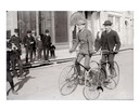
| Date: | 1890 |
|---|---|
| Description: | Two men ride their bicycles past curious on-lookers. |
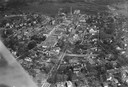
| Date: | 1925 |
|---|---|
| Description: | Aerial photograph taken as part of a survey by the Wisconsin Power and Light Company to promote economic development by emphasizing available buildings and... |
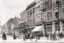
| Date: | 1912 |
|---|---|
| Description: | Street cars and busy pedestrian traffic mingle in this view of the 200 West Water Street block in downtown Milwaukee. |

| Date: | 1901 |
|---|---|
| Description: | A man tips his hat to a passing woman as horse-drawn carts and pedestrians navigate through the dirt and mud of Milwaukee streets, thereby illustrating tha... |
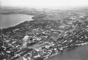
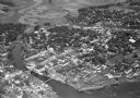
| Date: | |
|---|---|
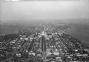
| Description: | Aerial view looking northeast towards the east side of Madison between Lake Monona and Lake Mendota, from Blair Street to the Yahara River. |
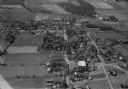
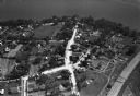
| Date: | 10 1928 |
|---|---|
| Description: | Aerial view of DeForest including residences and the surrounding countryside. |
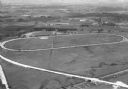
| Date: | 1930 |
|---|---|
| Description: | Aerial view of the Dane County fairgrounds, including several buildings and a track. |

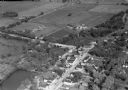
| Date: | 11 1928 |
|---|---|
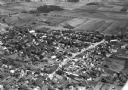
| Description: | Aerial view of Verona including businesses, houses, and the surrounding farm land. |
| Date: | 1930 |
|---|---|
| Description: | Aerial view of the town, including business, houses, and railroad tracks cutting through the town. |
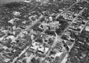
| Date: | 1930 |
|---|---|
| Description: | Aerial view looking southeast, towards the city, including the Wisconsin State Capitol, the central business district, the Capitol Square, both Lake Mendot... |
| Date: | |
|---|---|
| Description: | Aerial view of downtown area featuring the Wisconsin State Capitol. |
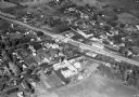
| Date: | 11 1928 |
|---|---|
| Description: | Aerial view of Stoughton including the central business district, the Yahara River, and the surrounding countryside. |

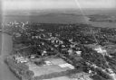
| Date: | 1930 |
|---|---|
| Description: | Aerial view of the University of Wisconsin-Madison campus, the State Historical Society of Wisconsin building, Lake Mendota, residential areas and the surr... |
| Date: | |
|---|---|
| Description: | Aerial view of the town, including the Wisconsin River, and the surrounding countryside. |
| Date: | 10 1928 |
|---|---|
| Description: | Aerial view of Belleville, including the central business disctrict and the surrounding countryside. |
| Date: | 1930 |
|---|---|
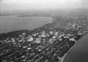
| Description: | Aerial view of the city and the Isthmus, the Wisconsin State Capitol, the downtown business district, and both Lake Mendota and Lake Monona. |
| Date: | 1930 |
|---|---|
| Description: | Aerial view of the city, including the Isthmus, the Wisconsin State Capitol, the downtown business district, Lake Mendota, and Lake Monona. |

| Date: | 10 1928 |
|---|---|
| Description: | Aerial view of Sun Prairie, including the central business district, residences, and the surrounding countryside stretching to the horizon. |
| Date: | 10 1928 |
|---|---|
| Description: | Aerial view of Sun Prairie, including the central business district, residences, and the surrounding countryside. |

| Date: | 1930 |
|---|---|
| Description: | Aerial view of the Wisconsin State Capitol, the surrounding businesses, and Lake Monona. |
If you didn't find the material you searched for, our Library Reference Staff can help.
Call our reference desk at 608-264-6535 or email us at: