 Filter: Categories of Wisconsin Historical Images
Filter: FORMAT_DIMENSIONS of 7 x 5 inches
Filter: Subject of land use, rural
Filter: Categories of Wisconsin Historical Images
Filter: FORMAT_DIMENSIONS of 7 x 5 inches
Filter: Subject of land use, rural
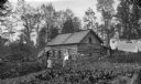
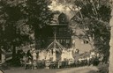
| Date: | 09 09 1895 |
|---|---|
| Description: | Log cabin of N.G. Willard on 80 acres of land. Two women, a young child, and an infant are posing outdoors in the yard. Laundry is hanging on lines on the ... |
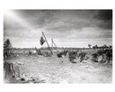
| Date: | |
|---|---|
| Description: | Pulling tree stumps in northern Wisconsin. A group of curious onlookers watches as workers load large stumps. A sign in the background reads: "Conrath Home... |
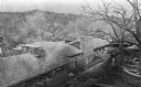
| Date: | 1913 |
|---|---|
| Description: | Elevated view of Taliesin. Taliesin is located in the vicinity of Spring Green. |
| Date: | 12 07 1915 |
|---|---|
| Description: | Three employees of International Harvester's Agricultural Extension Department working to free a car stuck in a muddy rural road. The original caption read... |

| Date: | 12 01 1962 |
|---|---|
| Description: | A farm road between fields in late sunlight, looking towards Mounds Creek in the vicinity of CTH F. |
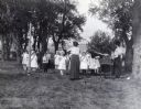
| Date: | 1919 |
|---|---|
| Description: | Miss Streeter leading school children in the "shoemaker's song". Another woman is standing near a Victrola. The children are outdoors under trees. Possibly... |
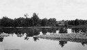
| Date: | |
|---|---|
| Description: | Calm river with a rocky island or outcrop in the foreground. |
| Date: | 1905 |
|---|---|
| Description: | Elevated view of students at the Hillside Home School performing a may pole dance while an audience looks on. Dance instruction at the school was provided ... |

| Date: | 1930 |
|---|---|
| Description: | Remains of the racetrack on the top of Blue Mound. |

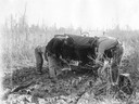
| Date: | |
|---|---|
| Description: | Colt nursing, mare grazing. There is a house in the background. |
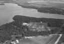
| Date: | 1930 |
|---|---|
| Description: | Aerial view of Turville Point and Turville farm, Lake Monona. |

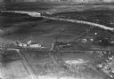
| Date: | 11 1928 |
|---|---|
| Description: | Aerial view of Verona including businesses, houses, and the surrounding farm land. |

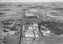
| Date: | 10 1928 |
|---|---|
| Description: | Aerial view of Sun Prairie, including the central business district, residences, and the surrounding countryside stretching to the horizon. |
| Date: | 1934 |
|---|---|
| Description: | Aerial view of the Jones dairy farm, Fort Atkinson, in winter. The Rock River is in the background. |

| Date: | 11 1928 |
|---|---|
| Description: | Aerial view of Stoughton, including the central business district, residential areas, the Yahara River, and the surrounding countryside. |

| Date: | 11 1928 |
|---|---|
| Description: | Aerial view residential areas of Windsor and the surrounding countryside. |

| Date: | 11 1928 |
|---|---|
| Description: | Aerial view of Black Earth residential area and the surrounding countryside. |

| Date: | 1930 |
|---|---|
| Description: | Aerial view of the town and the surrounding countryside. |

| Date: | 11 1928 |
|---|---|
| Description: | Aerial view of Cross Plains, including residences and the surrounding countryside. |
| Date: | 1932 |
|---|---|
| Description: | Aerial view of the Oscar Mayer meat packing plant, looking north, with the surrounding rural countryside. |
If you didn't find the material you searched for, our Library Reference Staff can help.
Call our reference desk at 608-264-6535 or email us at: