 Filter: Categories of Wisconsin Historical Images
Filter: FORMAT_DIMENSIONS of 6.5 x 4.5 inches
Filter: Subject of aerial photographs
Filter: Categories of Wisconsin Historical Images
Filter: FORMAT_DIMENSIONS of 6.5 x 4.5 inches
Filter: Subject of aerial photographs
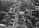
| Date: | 1924 |
|---|---|
| Description: | Aerial view of Green Bay's commercial district, bridges, and water. |
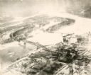
| Date: | 1935 |
|---|---|
| Description: | An aerial view of La Crosse and the Mississippi River with the bridge drawn in to show what the finished product would look like. |
| Date: | 1925 |
|---|---|
| Description: | Aerial view of buildings in the downtown area. |
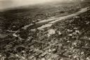
| Date: | 1938 |
|---|---|
| Description: | Aerial view of rivers, with Lake Michigan in upper right, train yards, and highway in lower left. |

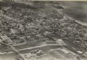
| Date: | 1922 |
|---|---|
| Description: | Aerial view of downtown with City Hall and Milwaukee River. |

| Date: | 1928 |
|---|---|
| Description: | University of Wisconsin-Madison, looking west. Lake Mendota and Picnic Point are in the upper right of the image. Bascom Hall, the Red Gym, the Wisconsin H... |
If you didn't find the material you searched for, our Library Reference Staff can help.
Call our reference desk at 608-264-6535 or email us at: