Filter: Categories of Wisconsin Historical Images
Filter: FORMAT_DIMENSIONS of 5 x 4 inches
Filter: Subject of landforms
Filter: Categories of Wisconsin Historical Images
Filter: FORMAT_DIMENSIONS of 5 x 4 inches
Filter: Subject of landforms
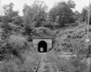
| Date: | 1924 |
|---|---|
| Description: | View from railroad tracks through covered railroad tunnel in hill. A sign on a telephone pole on the right reads: "Private Property / Thoroughfare / Keep O... |
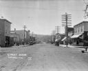
| Date: | 1922 |
|---|---|
| Description: | View down main street with storefronts on both sides, with large power lines along the sidewalks stretching into the distance, and a hill in the background... |

| Date: | 1874 |
|---|---|
| Description: | Bird's-eye map of Chippewa Falls. |

| Date: | 12 21 1882 |
|---|---|
| Description: | Bird's-eye map of Kaukauna, from the Appleton Post Annual Review. |

| Date: | 1892 |
|---|---|
| Description: | Bird's-eye map of Princeton, with an inset of the Residence of F.T. Yahr. Fox River loops to left of center, with one bridge; thirty-six businesses, reside... |

| Date: | 02 26 1887 |
|---|---|
| Description: | Bird's-eye map of Ashland, and the Apostle Islands in Lake Superior. Caption reads: "Ashland and the Apostle Islands." |
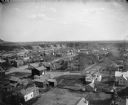
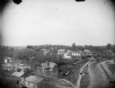
| Date: | |
|---|---|
| Description: | Elevated view of buildings in town with river in the background. |

| Date: | 1895 |
|---|---|
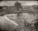
| Description: | View of a mill, sluice and dam on Waumandee Creek. The mill was built by John Oschner in 1863. Two products produced by the mill were White Rose Flour and ... |
| Date: | 1900 |
|---|---|
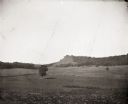
| Description: | Distant view of Black Hawk Lookout near the Wisconsin River. There is an open field with a single tree and a fence in the foreground. |
| Date: | 08 03 1946 |
|---|---|
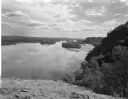
| Description: | View of the Wisconsin River from Cactus Bluff. |
| Date: | 05 19 1895 |
|---|---|
| Description: | A view from the bluff of group of men on the dredge bank of Buffalo Lake. |
| Date: | 05 19 1895 |
|---|---|
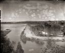
| Description: | Elevated view of the dam on the Fox River at Buffalo Lake. Houses and other buildings are visible in the background. |

| Date: | 02 06 1948 |
|---|---|
| Description: | Aerial photograph of Madison's west side looking northeast along Speedway Road. Visible are Forest Hill and Resurrection Cemeteries, West High School, Hoyt... |

| Date: | 02 06 1948 |
|---|---|
| Description: | Aerial view of west side, looking south along Glenway Street. Visible are the reservoir, Lake Wingra, Forest Hill and Resurrection Cemetery, Hoyt Park. Maj... |

| Date: | 02 06 1948 |
|---|---|
| Description: | Aerial photograph looking northwest across the reservoir on Glenway Street. Featured are Hoyt and Quarry Parks, Resurrection Cemetery. Major streets are Fr... |

| Date: | 02 06 1948 |
|---|---|
| Description: | Looking north along Glenway Street. Visible are the reservoir, Hoyt and Quarry Parks, Resurrection and Forest Hill Cemeteries, Rentschler Greenhouses, Fore... |

| Date: | 02 06 1948 |
|---|---|
| Description: | Looking southeast across Speedway Road. Visible are the reservoir on Glenway Street, Hoyt Park, Resurrection and Forest Hill cemeteries, Glenway Golf cours... |

| Date: | 02 06 1948 |
|---|---|
| Description: | Looking east along Regent Street with snow on the ground. Visible are Lake Wingra, Monona Bay, railroad causeway across Monona, Lake Mendota, Hoyt Park, We... |
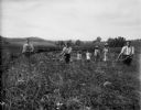
| Date: | |
|---|---|
| Description: | Three men scythe a field, possibly of wheat. Behind the men there are three children and a woman standing in a row. |
If you didn't find the material you searched for, our Library Reference Staff can help.
Call our reference desk at 608-264-6535 or email us at: