 Filter: Categories of Wisconsin Historical Images
Filter: FORMAT_DIMENSIONS of 5 x 4 inches
Filter: Subject of express highways
Filter: Categories of Wisconsin Historical Images
Filter: FORMAT_DIMENSIONS of 5 x 4 inches
Filter: Subject of express highways

| Date: | 09 1962 |
|---|---|
| Description: | The Mississippi River along Highway 35. |

| Date: | 1950 |
|---|---|
| Description: | Divided highway is South Chase Avenue between West Lincoln Avenue (2300) and East Oklahoma Avenue (3100). |

| Date: | 1930 |
|---|---|
| Description: | Exterior view of the Triangle filling station on Highway 12, which sold gasoline, ice, and other items. A man stands in front by the gas pump, and a map of... |

| Date: | 09 26 1949 |
|---|---|
| Description: | A car drives down the western portion of the newly opened Madison belt line. The view is looking northwest in the region of Gilbert road (also Whitney Way)... |
| Date: | 10 11 1950 |
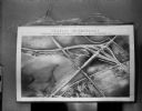
|---|---|
| Description: | Display illustrating the Highway Department's plan for separating highway traffic on Highways 13 and 14 (the Oregon Road) and Highway 12 (the new South Mad... |
| Date: | |
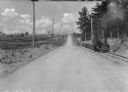
|---|---|
| Description: | View down center of a rural section of U.S. highway, with a small train running on railroad tracks alongside it. |
| Date: | |
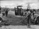
|---|---|
| Description: | A view of men grating the new surface of Roxboro Road, a section of the U.S. Highway. In the background is a steamroller. |
| Date: | |
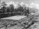
|---|---|
| Description: | A view on men resurfacing rural sections of U.S. Highway, with machinery and a small train running alongside the road. |

| Date: | |
|---|---|
| Description: | View down Ethan Allen highway. To the right stands "The House by the Side of the Road." |

| Date: | |
|---|---|
| Description: | Aerial view looking north along Stoughton Road from south of Pflaum Road. |
If you didn't find the material you searched for, our Library Reference Staff can help.
Call our reference desk at 608-264-6535 or email us at: