Filter: Categories of Wisconsin Historical Images
Filter: FORMAT_DIMENSIONS of 5 x 4 inches
Filter: Subject of aerial photographs
Filter: Categories of Wisconsin Historical Images
Filter: FORMAT_DIMENSIONS of 5 x 4 inches
Filter: Subject of aerial photographs
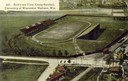
| Date: | 1908 |
|---|---|
| Description: | Aerial view of Camp Randall Stadium on the University of Wisconsin-Madison campus. Top image on Place File card. Caption reads: "Bird's-eye View, Camp Ra... |

| Date: | 1955 |
|---|---|
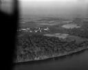
| Description: | Aerial view of town, with the Baraboo River. |

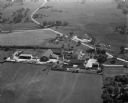
| Date: | |
|---|---|
| Description: | Aerial view looking southwest over the University of Wisconsin-Madison Stock Pavilion barns. |

| Date: | 1955 |
|---|---|
| Description: | Aerial view of river and town from a military airplane. |

| Date: | 05 05 1947 |
|---|---|
| Description: | Aerial view of the intersection of Pinckney, Main, and King Streets on the Madison Capitol Square. Kresge's, 27 East Main Street, can be seen at the upper ... |

| Date: | 05 05 1947 |
|---|---|
| Description: | Aerial view of Main, King, and Pinckney Streets intersection on Madison's Capitol Square. View is looking south down Pinckney Street. Kresge's, 27 East Mai... |

| Date: | 05 08 1947 |
|---|---|
| Description: | Aerial view of the Forsberg Paper Box Company, 2107 Fordem Avenue. View looks to the northeast toward Oscar Mayer. |

| Date: | 05 08 1947 |
|---|---|
| Description: | Aerial photograph of the Capitol Square area of Madison, looking to the southwest. |
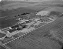
| Date: | 09 10 1947 |
|---|---|
| Description: | Aerial view of the River View Cannery. |

| Date: | 10 10 1947 |
|---|---|
| Description: | Aerial view of Dundas cannery. |
| Date: | 10 12 1947 |
|---|---|
| Description: | Aerial view of Cuba City Cannery. |
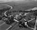
| Date: | 10 10 1947 |
|---|---|
| Description: | Aerial view of the Wisconsin Memorial Hospital run by the Veterans Administration on the north shore of Lake Mendota on the grounds of the Mendota State Ho... |

| Date: | 02 06 1948 |
|---|---|
| Description: | Aerial photograph of Madison's west side looking northeast along Speedway Road. Visible are Forest Hill and Resurrection Cemeteries, West High School, Hoyt... |

| Date: | 02 06 1948 |
|---|---|
| Description: | Aerial view of west side, looking south along Glenway Street. Visible are the reservoir, Lake Wingra, Forest Hill and Resurrection Cemetery, Hoyt Park. Maj... |

| Date: | 02 06 1948 |
|---|---|
| Description: | Aerial photograph looking northwest across the reservoir on Glenway Street. Featured are Hoyt and Quarry Parks, Resurrection Cemetery. Major streets are Fr... |

| Date: | 02 06 1948 |
|---|---|
| Description: | Looking north along Glenway Street. Visible are the reservoir, Hoyt and Quarry Parks, Resurrection and Forest Hill Cemeteries, Rentschler Greenhouses, Fore... |

| Date: | 02 06 1948 |
|---|---|
| Description: | Looking southeast across Speedway Road. Visible are the reservoir on Glenway Street, Hoyt Park, Resurrection and Forest Hill cemeteries, Glenway Golf cours... |

| Date: | 02 06 1948 |
|---|---|
| Description: | Looking east along Regent Street with snow on the ground. Visible are Lake Wingra, Monona Bay, railroad causeway across Monona, Lake Mendota, Hoyt Park, We... |
If you didn't find the material you searched for, our Library Reference Staff can help.
Call our reference desk at 608-264-6535 or email us at: