 Filter: Categories of Wisconsin Historical Images
Filter: FORMAT_DIMENSIONS of 4 x 5 inches
Filter: Subject of aerial photographs
Filter: Categories of Wisconsin Historical Images
Filter: FORMAT_DIMENSIONS of 4 x 5 inches
Filter: Subject of aerial photographs
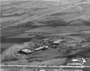
| Date: | 12 02 1970 |
|---|---|
| Description: | An aerial view of East Towne Shopping Center (now East Towne Mall) looking southeast across East Washington Avenue. |

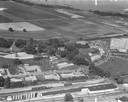
| Date: | 1956 |
|---|---|
| Description: | Aerial view of the Chicago, Milwaukee, and St. Paul Railroad station, roundhouse, and yard at the intersection of West Washington Avenue (across lower left... |

| Date: | 1958 |
|---|---|
| Description: | Aerial view of Craig Avenue and Crestwood Avenue. |
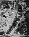
| Date: | 1958 |
|---|---|
| Description: | Aerial photograph showing the J.S. Timlin Lumber Company, 2702 University Avenue, as well as Doctors Park, the Veterans Hospital, and the First Unitarian S... |

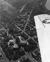
| Date: | 1950 |
|---|---|
| Description: | Aerial view of the Frank Lloyd-Wright-dsigned Unitarian Church under construction and the Veteran's Administration Hospital, also under construction, to th... |

| Date: | 1930 |
|---|---|
| Description: | Aerial view of Carson Park, Half Moon Lake and part of the West Side in the foreground. The municipal bath house is on the lake shore in the foreground. A ... |

| Date: | 1930 |
|---|---|
| Description: | Aerial view of city, with Eau Claire River is in the foreground with Milwaukee railroad bridge at left. Gillette Rubber Co. plant is in center with Omaha r... |

| Date: | 1931 |
|---|---|
| Description: | Aerial view looking north, with a small portion of the West Side (left), nearly all of the North Side and part of the business district of the East Side. A... |
| Date: | 1954 |
|---|---|
| Description: | Aerial view of the Wisconsin State Capitol, including a bit of the airplane wing. |

| Date: | 01 1946 |
|---|---|
| Description: | Aerial view of the Lake Mendota shoreline during the construction of the Edgewater Hotel. It is a view looking west over the junction of Langdon Street an... |
| Date: | 1954 |
|---|---|
| Description: | An air view of Madison including the Veterans Hospital, Forest Products Laboratory and University Avenue from Farley (lower edge), to Allen Streets. |

| Date: | 1928 |
|---|---|
| Description: | Aerial view of Madison looking southeast over the isthmus, showing the Four Lakes Country. Visible at the bottom is the Lake Mendota shoreline. At center, ... |

| Date: | 1955 |
|---|---|
| Description: | An air view of Madison's downtown area with the Wisconsin State Capitol and new State Office Buildings. |

| Date: | 1955 |
|---|---|
| Description: | Aerial view of Atwood Avenue, looking west towards Winnebago Street and "Schenk's Corners." |

| Date: | 1953 |
|---|---|
| Description: | Aerial view looking southeast over Madison's near east side. The Eagles Club at 1236 Jenifer Street / 1221 Williamson Street is under construction in the ... |
| Date: | 1955 |
|---|---|
| Description: | Aerial view of Wisconsin Dells. The wing of the airplane is in the left foreground. |
If you didn't find the material you searched for, our Library Reference Staff can help.
Call our reference desk at 608-264-6535 or email us at:


