 Filter: Categories of Wisconsin Historical Images
Filter: FORMAT_DIMENSIONS of 16 x 11 inches
Filter: Subject of water
Filter: Categories of Wisconsin Historical Images
Filter: FORMAT_DIMENSIONS of 16 x 11 inches
Filter: Subject of water

| Date: | 1908 |
|---|---|
| Description: | Colored map in perspective indicates railroad routes. Lake Winnebago and Oshkosh in center, area extends to Shawano (top right corner), Green Bay (bottom r... |
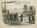
| Date: | 02 28 1863 |
|---|---|
| Description: | The First Regiment of the Louisiana Native Guards disembarking at Fort Macomb, Louisiana. The fort is adjacent to the Venetian Isles community, now legally... |
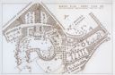
| Date: | 1931 |
|---|---|
| Description: | Fold-out map of the zoo inside a publication titled: "The Master Plan For Henry Vilas Park Zoo." Includes Lake Wingra, the lagoon, and the playground. |
If you didn't find the material you searched for, our Library Reference Staff can help.
Call our reference desk at 608-264-6535 or email us at:
