 Filter: Categories of Wisconsin Historical Images
Filter: FORMAT_DIMENSIONS of 14 x 11 inches
Filter: Subject of water
Filter: Categories of Wisconsin Historical Images
Filter: FORMAT_DIMENSIONS of 14 x 11 inches
Filter: Subject of water

| Date: | 1871 |
|---|---|
| Description: | Drawing of the Peshtigo Fire, showing people seeking refuge in the Peshtigo River. |
| Date: | 1900 |
|---|---|
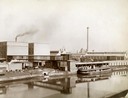
| Description: | View across water towards a boat called "The Imperial" moored along the dock at the McCormick Reaper Works. The boat is loaded with freight. In the backgro... |
| Date: | 1900 |
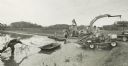
|---|---|
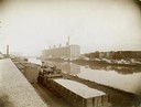
| Description: | McCormick Reaper Works and wood shop stock yard as seen from across a canal. In the foreground is a rail yard with a small engine and rail cars. The factor... |
| Date: | 1900 |
|---|---|
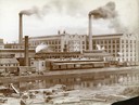
| Description: | Southwest panorama of the McCormick Reaper Works factory and rail yard as seen across a canal. Workers can be seen unloading wood. |

| Date: | 1878 |
|---|---|
| Description: | Bird's-eye map of Chilton with insets of points of interest, including P.H. Becker's Brewery, Chilton House, and Gutheil's Block. |

| Date: | 1829 |
|---|---|
| Description: | Drawing of Cassville depicting a horse cart on the river's edge, with men and boats. |
| Date: | 1955 |
|---|---|
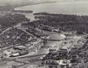
| Description: | Aerial view of "the island" with the Marathon Corporation paper mills. The Fox River flowing out of Lake Winnebago separates the two cities, Neenah and Men... |
| Date: | 10 08 1997 |
|---|---|
| Description: | Group of men harvesting cranberries. |

| Date: | 1951 |
|---|---|
| Description: | Aerial view of Jones Island and garbage disposal plant. |

| Date: | 1870 |
|---|---|
| Description: | Metal bridge over river with three men standing near the railing. |
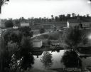
| Date: | 1900 |
|---|---|
| Description: | Elevated view of multiple buildings and a body of water on the farm of S.J. Peabody. Three men are riding in a horse-drawn carriage along the water in the ... |

| Date: | 1940 |
|---|---|
| Description: | Aerial view of the west side of the University of Wisconsin-Madison Campus looking towards Bascom Hill. Lake Mendota is in the background on the right. |

| Date: | 1955 |
|---|---|
| Description: | An aerial view of Middleton. In the foreground is a baseball field, and beyond are houses, woods, fields, and Lake Mendota. |
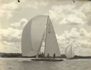
| Date: | 07 1959 |
|---|---|
| Description: | View across water of the Senta III, owned by Ernst Schmidt of Black Point Estate, competes in the Class A Regatta at Pewaukee Lake. The skipper is B... |

| Date: | 07 07 1954 |
|---|---|
| Description: | Aerial view of group of buildings on the north east campus of the University of Wisconsin, including the Historical Library, University Library, old Scienc... |

| Date: | 1921 |
|---|---|
| Description: | A plat map of Mequon, Wisconsin. Text at top reads: "T. 9N. R.21 E MEQUON T. 9N. R.22 E." |
If you didn't find the material you searched for, our Library Reference Staff can help.
Call our reference desk at 608-264-6535 or email us at:


