Filter: Categories of Wisconsin Historical Images
Filter: FORMAT_DIMENSIONS of 14 x 11 inches
Filter: Subject of human settlements
Filter: Subject of botany
Filter: Categories of Wisconsin Historical Images
Filter: FORMAT_DIMENSIONS of 14 x 11 inches
Filter: Subject of human settlements
Filter: Subject of botany

| Date: | 1878 |
|---|---|
| Description: | Bird's-eye map of Chilton with insets of points of interest, including P.H. Becker's Brewery, Chilton House, and Gutheil's Block. |

| Date: | 1829 |
|---|---|
| Description: | Drawing of Cassville depicting a horse cart on the river's edge, with men and boats. |

| Date: | 1953 |
|---|---|
| Description: | Captain John Cotton residence. Also known as "Beaupre," this Greek Revival style house was built in 1842 for Cotton, a retired U.S. Army officer. |
| Date: | 10 1948 |
|---|---|
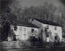
| Description: | The Pendarvis and Trelawny homes on Shake Rag Street, originally Cornish miner's cottages. |

| Date: | 1980 |
|---|---|
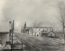
| Description: | Telephone lines and trees are in the foreground of this photograph. Tucked behind them is the St. Joseph Church, which was located at 1905 West Beltline Hi... |

| Date: | 11 1980 |
|---|---|
| Description: | Presumably the back side of a service station located at 2663 South Stoughton Road, south of McFarland. |
| Date: | 1980 |
|---|---|
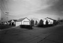
| Description: | Roads and telephone lines intersect at the corner of the block, 4021 North 62nd (Rear). |

| Date: | 04 1981 |
|---|---|
| Description: | A grand horseshoe-shaped staircase in the center of the entrance to this Grecian-style building on Highway 151. The Hospital and home stand tall with large... |
| Date: | 04 1981 |
|---|---|
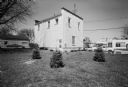
| Description: | Exterior view from lawn of a white brick bank. Tiny evergreen trees are planted outside and cars are parked alongside the road. |

| Date: | 04 1981 |
|---|---|
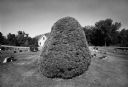
| Description: | View of the Graceland Cemetery. There are houses in the background and trees scattered throughout the plots. |
| Date: | 04 1981 |
|---|---|
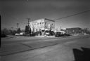
| Description: | View across street of parked cars along curb in front of the Suburban Inn, formerly the Park Hotel, on the 300 block of Broom Street. Next door on the righ... |

| Date: | 05 1981 |
|---|---|
| Description: | View from across street of house on 2051 Camilla Street. |

| Date: | 03 1981 |
|---|---|
| Description: | View from parking lot of side of building at the southwest corner of Aurora and Elmwood Avenue. Other buildings are in the background. |

| Date: | 1900 |
|---|---|
| Description: | A man is farming a hillside using a McCormick grain binder led by a team of two horses. |

| Date: | 1900 |
|---|---|
| Description: | A man is using a horse-drawn McCormick grain binder on a hillside overlooking a valley with houses and other buildings. |
If you didn't find the material you searched for, our Library Reference Staff can help.
Call our reference desk at 608-264-6535 or email us at: