 Filter: Categories of Wisconsin Historical Images
Filter: FORMAT_DIMENSIONS of 11 x 17 inches
Filter: Subject of land
Filter: Categories of Wisconsin Historical Images
Filter: FORMAT_DIMENSIONS of 11 x 17 inches
Filter: Subject of land

| Date: | 1853 |
|---|---|
| Description: | Plan no. 3. Scale 2000 feet to one inch. |

| Date: | 1839 |
|---|---|
| Description: | Map of a canal route to avoid the principal rapids of the Neenah or Fox River between Lake Winnebago and Green Bay. |
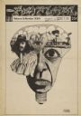
| Date: | 11 22 1968 |
|---|---|
| Description: | Cover of "Spokane Natural," an underground newspaper, depicting lightbulb form, comprised of a man's face, a landscape, and other elements. "lns, ups" in u... |

| Date: | 1910 |
|---|---|
| Description: | Left half of a plat map of Hustisford in Dodge County. |

| Date: | 1910 |
|---|---|
| Description: | The right half of a plat map of Hustisford in Dodge County. |
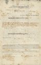
| Date: | 01 29 1853 |
|---|---|
| Description: | Document of agreement between Oren Johnson of Dodge County and the La Crosse and Milwaukee Rail Road Company. Johnson agreed to pay $600 plus 8% annual int... |
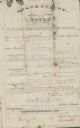
| Date: | 07 09 1853 |
|---|---|
| Description: | Legal title to Oren Johnson's mortgaged land in Dodge County. The La Crosse and Milwaukee Rail Road Company assessed the land for $1,500. |
If you didn't find the material you searched for, our Library Reference Staff can help.
Call our reference desk at 608-264-6535 or email us at: