 Filter: Categories of Wisconsin Historical Images
Filter: FORMAT_DIMENSIONS of 11 x 14 inches
Filter: Subject of water
Filter: Categories of Wisconsin Historical Images
Filter: FORMAT_DIMENSIONS of 11 x 14 inches
Filter: Subject of water

| Date: | 06 07 1954 |
|---|---|
| Description: | Aerial view looking north from near the city's southwestern limits in 1954. Shows text indicating Midvale Boulevard, Odana Road, Tokay Boulevard, Mineral P... |

| Date: | 07 10 1949 |
|---|---|
| Description: | Aerial view of Minocqua showing the surrounding lakes. |

| Date: | 1859 |
|---|---|
| Description: | This 1859 railroad map shows counties, cities, rivers and lakes in the entire state of Wisconsin. It includes an inset depicting the railroads in Milwaukee... |

| Date: | 1950 |
|---|---|
| Description: | Harbor area of Jones Island and garbage disposal plant, Stratton Grain Co., and more. |
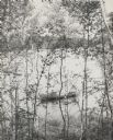
| Date: | 1930 |
|---|---|
| Description: | View through birch trees looking down at two men fishing from a rowboat near the shoreline. Another boat is tethered to the shore nearby. |
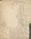
| Date: | 1929 |
|---|---|
| Description: | An unsigned, hand-drawn map of properties owned by members of the Brumder family on the northwest shore of Pine Lake in 1929. Named Villa Henrietta, the pr... |
If you didn't find the material you searched for, our Library Reference Staff can help.
Call our reference desk at 608-264-6535 or email us at: