 Filter: Categories of Wisconsin Historical Images
Filter: FORMAT_DIMENSIONS of 10 x 8 inches
Filter: Creator Name of Vesey, Richard
Filter: Categories of Wisconsin Historical Images
Filter: FORMAT_DIMENSIONS of 10 x 8 inches
Filter: Creator Name of Vesey, Richard
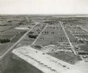
| Date: | 1955 |
|---|---|
| Description: | An aerial view of Truax Field, now also called Dane County Regional Airport. In addition to commercial flights, Truax Field is also home to the Army Nation... |
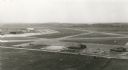
| Date: | 1955 |
|---|---|
| Description: | An aerial view at Truax Field showing the Municipal Airport Administration Building. |

| Date: | 1951 |
|---|---|
| Description: | View from road of the Merrimac ferry approaching shore with several automobiles and a large truck aboard. In the foreground is a sign that reads: "Keep Bac... |
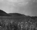
| Date: | 03 1953 |
|---|---|
| Description: | View across a prairie toward wooded hills. Caption reads: "Wisconsin River Valley. Bluffs as seen from Highway 80 west of Avoca, Wis." |

| Date: | 1950 |
|---|---|
| Description: | View of an automobile traveling north on Highway 35, near the Mississippi River. Railroad tracks run between the road and the river. In the background are ... |
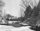
| Date: | 1952 |
|---|---|
| Description: | A winter view of the Mullet River near Crystal Lake. In the background is a house on a rise. |
| Date: | 1952 |
|---|---|
| Description: | Rawley Point Lighthouse, located in the Point Beach State Forest. It is 111 feet tall. |
| Date: | 1952 |
|---|---|
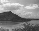
| Description: | View of Perrot State Park from the opposite shore of the Mississippi river. |
| Date: | 1950 |
|---|---|
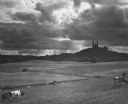
| Description: | Dramatic view of Holy Hill against a sky full of clouds. In the foreground, cows are grazing in fenced fields. |

| Date: | 1956 |
|---|---|
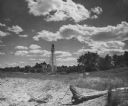
| Description: | A harvest moon over a farm. Fence posts are in the foreground. |

| Date: | 1954 |
|---|---|
| Description: | Corn shocks stand in a foggy field and trees cover a rise in the background. |
If you didn't find the material you searched for, our Library Reference Staff can help.
Call our reference desk at 608-264-6535 or email us at: