 Filter: Categories of Wisconsin Historical Images
Filter: FORMAT_DIMENSIONS of 10 x 8 Inches
Filter: Creator Name of Newhouse, John
Filter: Categories of Wisconsin Historical Images
Filter: FORMAT_DIMENSIONS of 10 x 8 Inches
Filter: Creator Name of Newhouse, John
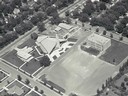
| Date: | |
|---|---|
| Description: | Aerial view of Our Lady Queen of Peace Church. |
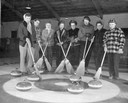
| Date: | |
|---|---|
| Description: | A female curling team poses with their brooms and stones for a portrait. |

| Date: | 1950 |
|---|---|
| Description: | A teenager sitting on a bed talking on the telephone. |

| Date: | 1950 |
|---|---|
| Description: | A young child examines a children's book with her grandmother. |

| Date: | 1950 |
|---|---|
| Description: | A woman poses her kitchen with all of the modern conveniences. |

| Date: | 1950 |
|---|---|
| Description: | Nurse with a young girl patient and a container of blood. |
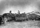
| Date: | 1950 |
|---|---|
| Description: | A stationary McCormick-Deering thresher in action at the E.J. Shuster Farm. |

| Date: | 1950 |
|---|---|
| Description: | Woman with children grilling hot dogs and wieners at the beach. |

| Date: | |
|---|---|
| Description: | Aerial view of a full Camp Randall Stadium during half-time of a football game. The band is on the field in formation to spell "UW." |

| Date: | 1956 |
|---|---|
| Description: | Aerial view of St. Mary's Hospital and the surrounding residential neighborhoods. |

| Date: | 1954 |
|---|---|
| Description: | View from atop a building across Wisconsin Avenue of the Fuller Opera House during its demolition. |

| Date: | 1968 |
|---|---|
| Description: | Aerial view looking southwest, with Lake Mendota at right and East Gorham Street running from the bottom left corner. Lincoln School is in the foreground, ... |

| Date: | 1960 |
|---|---|
| Description: | Air view of the Lake Mendota Shore looking east. The Edgewater Hotel and Kennedy Manor are at bottom center with Lake Mendota at left. James Madison Park i... |

| Date: | 1962 |
|---|---|
| Description: | Air view in winter of the Triangle Redevelopment Project looking east with Regent Street running along the left edge, W. Washington Avenue along the top, a... |

| Date: | 1965 |
|---|---|
| Description: | Air view of the west end of University of Wisconsin-Madison campus with U.W. Hospital and U.W. athletic fields at top. Campus Drive and University Avenue r... |

| Date: | 1968 |
|---|---|
| Description: | Air view of the University of Wisconsin-Madison campus looking north to Lake Mendota. Picnic Point, currently part of the Lakeshore Nature Preserve, and Ca... |

| Date: | 1962 |
|---|---|
| Description: | Aerial view of the Hilldale Shopping Center and environs. Anchor store is Gimbels. N. Midvale Boulevard runs left to right. The State Department of Transpo... |

| Date: | 1967 |
|---|---|
| Description: | Air view looking north toward Lake Mendota. The intersection of West Washington Ave. and S. Park Street is at bottom center. The Triangle Redevelopment Pro... |

| Date: | 1960 |
|---|---|
| Description: | Air view focused on the Greenbush neighborhood of Madison prior to its demolition for the Triangle Redevelopment Project. Monona Bay and Brittingham Park a... |

| Date: | |
|---|---|
| Description: | Aerial view of the Greenbush neighborhood in winter partially demolished for the Triangle Redevelopment Project. Monona Bay and Brittingham park are at rig... |
If you didn't find the material you searched for, our Library Reference Staff can help.
Call our reference desk at 608-264-6535 or email us at: