Filter: Categories of Wisconsin Historical Images
Filter: County of Wood
Filter: Year of 1800-1899
Filter: Categories of Wisconsin Historical Images
Filter: County of Wood
Filter: Year of 1800-1899

| Date: | 1878 |
|---|---|
| Description: | This 1878 map of Wood County, Wisconsin, shows the township and range grid, towns, sections, cities, villages and post offices, landownership, roads, railr... |

| Date: | 1892 |
|---|---|
| Description: | 1 map on 4 sheets : col., mounted on cloth ; Shows landownership, roads and railroads, townships, and selected buildings. Includes "Professional directory... |

| Date: | 1858 |
|---|---|
| Description: | Map showing roads, mills, and rivers. Date conjectured from presence of Ensign’s Mill and Pitt’s Mill and location of Nekoosa. |

| Date: | 06 22 1891 |
|---|---|
| Description: | This 1891 manuscript map depicts Cranberry Creek and wetlands in part of the Town of Port Edwards, Wood County, Wisconsin. Elevations and falls in the cree... |
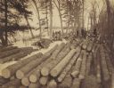
| Date: | 1890 |
|---|---|
| Description: | 90,000 feet of pine logs floating in the storage/sorting pond at the Arpin Lumber Company sawmill. The sawmill and other buildings are in the background. O... |

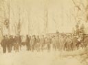
| Date: | 1880 |
|---|---|
| Description: | View of flood damage, showing wrecked buildings along the Wisconsin River waterfront. |
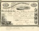
| Date: | 09 09 1861 |
|---|---|
| Description: | Nekoosa Lumbering Company stock certificate for eighty shares made out to Moses M. Strong. Each share costs $50.00. |
If you didn't find the material you searched for, our Library Reference Staff can help.
Call our reference desk at 608-264-6535 or email us at: