Filter: Categories of Wisconsin Historical Images
Filter: County of Wood
Filter: Subject of transportation
Filter: Year of 1800-1899
Filter: Categories of Wisconsin Historical Images
Filter: County of Wood
Filter: Subject of transportation
Filter: Year of 1800-1899
| Date: | 09 09 1895 |
|---|---|
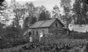
| Description: | Log cabin of N.G. Willard on 80 acres of land. Two women, a young child, and an infant are posing outdoors in the yard. Laundry is hanging on lines on the ... |

| Date: | 1874 |
|---|---|
| Description: | Bird's-eye map of Grand Rapids. |

| Date: | 1883 |
|---|---|
| Description: | Bird's-eye map of Marshfield, with one vignette. |
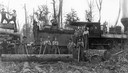
| Date: | 1888 |
|---|---|
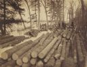
| Description: | A logging crew of the Upham Lumber Company, together with the company's locomotive, "Old Vanderbilt," formerly the Wisconsin Central Railroad's Engine No #... |
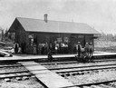
| Date: | 1891 |
|---|---|
| Description: | Elevated view across railroad tracks of the Wisconsin Central Railroad depot. Virtually the entire population of Sherry is thought to be standing on the pl... |
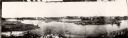
| Date: | 1885 |
|---|---|
| Description: | A panoramic view of the east bank of the Wisconsin River from the Green Bay & Western Railway bridge to the wagon bridge. |
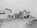
| Date: | 1895 |
|---|---|
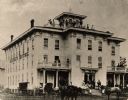
| Description: | View of several buildings and horse-drawn stagecoaches in Vesper. |
| Date: | 1884 |
|---|---|
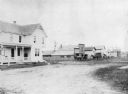
| Description: | The hardware store opened and run by Joseph Rumenopp located on the corner of Central Avenue and East Second Street. The store was later sold to J.J. Willi... |

| Date: | 1878 |
|---|---|
| Description: | This 1878 map of Wood County, Wisconsin, shows the township and range grid, towns, sections, cities, villages and post offices, landownership, roads, railr... |

| Date: | 1892 |
|---|---|
| Description: | 1 map on 4 sheets : col., mounted on cloth ; Shows landownership, roads and railroads, townships, and selected buildings. Includes "Professional directory... |

| Date: | 1858 |
|---|---|
| Description: | Map showing roads, mills, and rivers. Date conjectured from presence of Ensign’s Mill and Pitt’s Mill and location of Nekoosa. |
If you didn't find the material you searched for, our Library Reference Staff can help.
Call our reference desk at 608-264-6535 or email us at: