 Filter: Categories of Wisconsin Historical Images
Filter: County of Wood
Filter: Subject of cities and towns
Filter: Subject of transportation
Filter: Categories of Wisconsin Historical Images
Filter: County of Wood
Filter: Subject of cities and towns
Filter: Subject of transportation

| Date: | |
|---|---|
| Description: | Elevated view from hill toward a bridge over the Wisconsin River. |

| Date: | |
|---|---|
| Description: | View of Grand Avenue Bridge, built in 1922. The Commercial Hotel stands on the right bank; it began operation in 1881. |

| Date: | |
|---|---|
| Description: | Elevated view over water toward a horse and carriage and pedestrians crossing the Grand Avenue Bridge, built in 1922. Smokestacks and other buildings are o... |
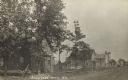
| Date: | 09 12 1911 |
|---|---|
| Description: | Street view of two-story residential houses and buildings. A horse-drawn wagon sitting outside a store is visible on the far right. Caption reads: "Street ... |
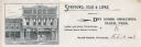
| Date: | |
|---|---|
| Description: | Letterhead of Spafford, Cole & Lipke of Grand Rapids, Wisconsin, general merchandise dealers, with a front view of its two side-by-side buildings; the stor... |

| Date: | 1878 |
|---|---|
| Description: | This 1878 map of Wood County, Wisconsin, shows the township and range grid, towns, sections, cities, villages and post offices, landownership, roads, railr... |

| Date: | 1902 |
|---|---|
| Description: | This map from the early years of the 20th century shows the township and range grid, sections, cities and villages, landownership, roads and railroads, and... |

| Date: | 1910 |
|---|---|
| Description: | This early 20th century map of Wood County, Wisconsin, shows the township and range grid, towns, sections, cities and villages, roads and railroads, and st... |

| Date: | 1892 |
|---|---|
| Description: | 1 map on 4 sheets : col., mounted on cloth ; Shows landownership, roads and railroads, townships, and selected buildings. Includes "Professional directory... |

| Date: | 1858 |
|---|---|
| Description: | Map showing roads, mills, and rivers. Date conjectured from presence of Ensign’s Mill and Pitt’s Mill and location of Nekoosa. |

| Date: | 1992 |
|---|---|
| Description: | This 1992 map of Wood County, Wisconsin, shows towns, sections, cities and villages, highways and roads, railroads, and lakes and streams. An inset map of ... |

| Date: | 06 1931 |
|---|---|
| Description: | This map is a photocopy of a map that has been hand-colored and shows streets, the Wisconsin River, Mill Pond, and points of interest that include a school... |

| Date: | |
|---|---|
| Description: | Elevated view from bluff of Grand Rapids and the Wisconsin River. |

| Date: | 1907 |
|---|---|
| Description: | View of the intersection of Front and Center Streets. The First National Bank is on the corner. Horses and buggies are in the streets. Caption reads: "Fron... |

| Date: | 1913 |
|---|---|
| Description: | Hand-colored view of Grand Avenue looking east toward the bridge. The street is lined with businesses. Caption reads: "Grand Avenue Looking East, Grand Rap... |
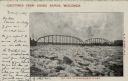
| Date: | 1907 |
|---|---|
| Description: | View of an ice jam near a Grand Rapids bridge in the Wisconsin River. Caption at top reads: "Greetings from Grand Rapids, Wis." Caption at bottom reads: "I... |

| Date: | 1908 |
|---|---|
| Description: | View of an intersection in central Grand Rapids. Identified are: First Street on the left, the city library in the center, and Baker Street on the right. A... |

| Date: | 1911 |
|---|---|
| Description: | Elevated view of the water tower, with Grand Rapids laid out behind it. |

| Date: | 1916 |
|---|---|
| Description: | Hand-colored postcard of the Dixon Hotel. A large sign is above the entrance, and a bar is in the basement. A car is parked at the curb on the right. Capti... |

| Date: | 1913 |
|---|---|
| Description: | View from shoreline towards a stone pedestrian bridge on a river. The city skyline is in the distance. Caption reads: "Strollers Bridge, Grand Rapids, Wis.... |
If you didn't find the material you searched for, our Library Reference Staff can help.
Call our reference desk at 608-264-6535 or email us at: