Filter: Categories of Wisconsin Historical Images
Filter: County of Wood
Filter: Subject of cities and towns
Filter: Subject of land
Filter: Categories of Wisconsin Historical Images
Filter: County of Wood
Filter: Subject of cities and towns
Filter: Subject of land
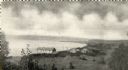
| Date: | 1910 |
|---|---|
| Description: | View from pier towards the Old Mission in La Pointe on Madeline Island. Men are sitting at the shoreline. Caption reads: "Apostle Islands, Wis. Madeline Is... |

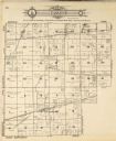
| Date: | 1878 |
|---|---|
| Description: | This 1878 map of Wood County, Wisconsin, shows the township and range grid, towns, sections, cities, villages and post offices, landownership, roads, railr... |

| Date: | 1902 |
|---|---|
| Description: | This map from the early years of the 20th century shows the township and range grid, sections, cities and villages, landownership, roads and railroads, and... |

| Date: | 1910 |
|---|---|
| Description: | This early 20th century map of Wood County, Wisconsin, shows the township and range grid, towns, sections, cities and villages, roads and railroads, and st... |

| Date: | 1892 |
|---|---|
| Description: | 1 map on 4 sheets : col., mounted on cloth ; Shows landownership, roads and railroads, townships, and selected buildings. Includes "Professional directory... |

| Date: | 1858 |
|---|---|
| Description: | Map showing roads, mills, and rivers. Date conjectured from presence of Ensign’s Mill and Pitt’s Mill and location of Nekoosa. |

| Date: | |
|---|---|
| Description: | Elevated view from bluff of Grand Rapids and the Wisconsin River. |
If you didn't find the material you searched for, our Library Reference Staff can help.
Call our reference desk at 608-264-6535 or email us at: