Filter: Categories of Wisconsin Historical Images
Filter: County of Wood
Filter: Type of Map or Atlas
Filter: Year of 1900-1999
Filter: Categories of Wisconsin Historical Images
Filter: County of Wood
Filter: Type of Map or Atlas
Filter: Year of 1900-1999

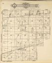
| Date: | 1902 |
|---|---|
| Description: | This map from the early years of the 20th century shows the township and range grid, sections, cities and villages, landownership, roads and railroads, and... |

| Date: | 1910 |
|---|---|
| Description: | This early 20th century map of Wood County, Wisconsin, shows the township and range grid, towns, sections, cities and villages, roads and railroads, and st... |

| Date: | 1992 |
|---|---|
| Description: | This 1992 map of Wood County, Wisconsin, shows towns, sections, cities and villages, highways and roads, railroads, and lakes and streams. An inset map of ... |

| Date: | 06 1931 |
|---|---|
| Description: | This map is a photocopy of a map that has been hand-colored and shows streets, the Wisconsin River, Mill Pond, and points of interest that include a school... |
If you didn't find the material you searched for, our Library Reference Staff can help.
Call our reference desk at 608-264-6535 or email us at: