Filter: Categories of Wisconsin Historical Images
Filter: County of Waupaca
Filter: Year of 1900-1999
Filter: Categories of Wisconsin Historical Images
Filter: County of Waupaca
Filter: Year of 1900-1999
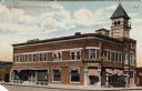
| Date: | 1909 |
|---|---|
| Description: | Colorized photographic view from street towards the State Bank building on a corner. Caption reads: "State Bank, Clintonville, Wis." |

| Date: | 1910 |
|---|---|
| Description: | Black and white postcard view looking up unpaved road and sidewalk towards the Ward House. Caption reads: "Ward House, Clintonville, Wis." |
| Date: | 1930 |
|---|---|
| Description: | View of new bridge over a river, and on the other side the Folkman's store. Caption reads: "New Bridge & Folkman's Store, Clintonville, Wis." |

| Date: | 07 24 1912 |
|---|---|
| Description: | View down street towards the dynamiting of the bridge over the Pigeon River during the flood. Caption reads: "Dynamiting the Bridge, Flood of July 24, 1912... |

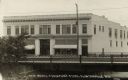
| Date: | 1920 |
|---|---|
| Description: | A view of one of the two-course reinforced concrete pavements constructed by the C. Petersen Construction Company, of Kenosha, under the direction of W.F. ... |

| Date: | 1910 |
|---|---|
| Description: | View down wooden sidewalk towards an unpaved street on the left, and a residential are with houses with large porches on the right. A group of people are w... |
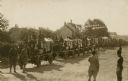
| Date: | 1914 |
|---|---|
| Description: | Slightly elevated view of the United States Military surveying four wheel drive (FWD) trucks, manufactured in Clintonvlle, carrying supply boxes. Caption r... |
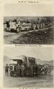
| Date: | 1918 |
|---|---|
| Description: | Postcard with two photographs of four wheel drive (F.W.D.) trucks, which were manufactured in Clintonville, Wisconsin. They are carrying supplies and troop... |
| Date: | 1944 |
|---|---|
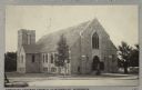
| Description: | View across street towards the Christus Lutheran Church. Caption reads: "Christus Lutheran Church, Clintonville, Wisconsin." |

| Date: | 1960 |
|---|---|
| Description: | View of St. Martin Lutheran Church (Missouri Synod), 8th Street and S. Clinton Avenue. |

| Date: | 1974 |
|---|---|
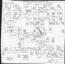
| Description: | This map includes a diagram on the bottom left margin showing civil towns, a township numbering system, state highways, roads, lakes, and a legend on the r... |

| Date: | 1901 |
|---|---|
| Description: | This map shows landownership and acreages, townships and sections, and selected buildings. |
| Date: | 1971 |
|---|---|
| Description: | This map is a photocopy of a plat created in 1966 by Malcolm Rosholt which shows the community as it appeared in 1856. The map includes land owned by Norwe... |
| Date: | 1922 |
|---|---|
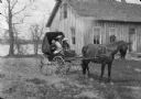
| Description: | Group portrait of Christine Peterson and her two children, Laurie and Muriel, sitting in a buggy pulled by a single horse. In the background is a building ... |
| Date: | 1913 |
|---|---|
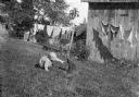
| Description: | View across yard towards James Peterson playing with a cat. In the background, laundry is hanging on a clothesline and beehives are standing at the edge of... |
| Date: | 1913 |
|---|---|
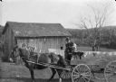
| Description: | View across yard towards Carl Peterson sitting next to his son James holding the reins of two horses while sitting on a wagon. In the background are farm b... |

| Date: | 1922 |
|---|---|
| Description: | View across field towards James Peterson sitting on a blanket holding a basket. In the background are trees. |
| Date: | 1922 |
|---|---|
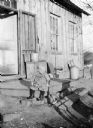
| Description: | View across the yard towards James Peterson sitting on a landing near the open door of a house or farm building with two windows. Stacked on a crate near t... |
| Date: | 1922 |
|---|---|
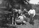
| Description: | Two men are posing with a cow in a field under trees. One of the men is sitting as if milking the cow with one hand, while he is drinking from a bottle wit... |
If you didn't find the material you searched for, our Library Reference Staff can help.
Call our reference desk at 608-264-6535 or email us at: