 Filter: Categories of Wisconsin Historical Images
Filter: County of Waupaca
Filter: Year of 1800-1899
Filter: Year of 1870-1879
Filter: Categories of Wisconsin Historical Images
Filter: County of Waupaca
Filter: Year of 1800-1899
Filter: Year of 1870-1879

| Date: | 1871 |
|---|---|
| Description: | Birds eye map of New London depicts street names and street locations, houses, trees, the bridge, Wolf River, and the bayou. At the bottom of the map, a re... |
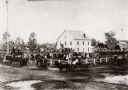
| Date: | 1870 |
|---|---|
| Description: | View of an unidentified ceremony taking place at the public square on the steps of the original Waupaca County Courthouse. |
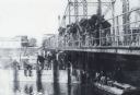
| Date: | 1870 |
|---|---|
| Description: | A large group of men are snagging sturgeon from a bridge over the Wolf River. A sturgeon is hanging from a line. More men are sitting on a bridge support, ... |
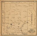
| Date: | 1870 |
|---|---|
| Description: | This 1870 map of Waupaca County, Wisconsin, shows the township and range grid, towns, cities and villages, and lakes and streams. |
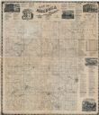
| Date: | 1874 |
|---|---|
| Description: | This map shows townships and sections, land ownership and acreages, churches, schools, cemeteries, roads, railroads, and projected railroads. The map inclu... |
If you didn't find the material you searched for, our Library Reference Staff can help.
Call our reference desk at 608-264-6535 or email us at:

