Filter: Categories of Wisconsin Historical Images
Filter: County of Waupaca
Filter: Type of Map or Atlas
Filter: Year of 1900-1999
Filter: Categories of Wisconsin Historical Images
Filter: County of Waupaca
Filter: Type of Map or Atlas
Filter: Year of 1900-1999
| Date: | 1976 |
|---|---|
| Description: | This is a guide to the original bikeway and additions. The front of the guide includes a map of Wisconsin, a map of the entire bikeway, and one route map. ... |

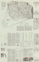
| Date: | 1941 |
|---|---|
| Description: | This pictorial map shows sites related to Indian legends, mounds, and trails in the Chain O' Lakes region in southwestern Waupaca County, Wisconsin. |

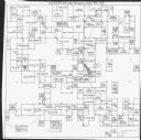
| Date: | 1974 |
|---|---|
| Description: | This map includes a diagram on the bottom left margin showing civil towns, a township numbering system, state highways, roads, lakes, and a legend on the r... |

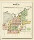
| Date: | 1901 |
|---|---|
| Description: | This map shows landownership and acreages, townships and sections, and selected buildings. |
| Date: | 1971 |
|---|---|
| Description: | This map is a photocopy of a plat created in 1966 by Malcolm Rosholt which shows the community as it appeared in 1856. The map includes land owned by Norwe... |
If you didn't find the material you searched for, our Library Reference Staff can help.
Call our reference desk at 608-264-6535 or email us at: