 Filter: Categories of Wisconsin Historical Images
Filter: County of Waukesha
Filter: Year of 1900-1999
Filter: Year of 1910-1919
Filter: Type of Map or Atlas
Filter: Categories of Wisconsin Historical Images
Filter: County of Waukesha
Filter: Year of 1900-1999
Filter: Year of 1910-1919
Filter: Type of Map or Atlas
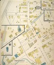
| Date: | 10 1914 |
|---|---|
| Description: | Page 2 of a Sanborn-Perris map of Pewaukee. |

| Date: | 1911 |
|---|---|
| Description: | This 1911 map from the U.S. Post Office Dept. shows rural delivery routes, active and discontinued post offices, selected rural landowners and houses, chur... |
If you didn't find the material you searched for, our Library Reference Staff can help.
Call our reference desk at 608-264-6535 or email us at:
