 Filter: Categories of Wisconsin Historical Images
Filter: County of Waukesha
Filter: Year of 1900-1999
Filter: Type of Map or Atlas
Filter: Year of 1920-1929
Filter: Categories of Wisconsin Historical Images
Filter: County of Waukesha
Filter: Year of 1900-1999
Filter: Type of Map or Atlas
Filter: Year of 1920-1929
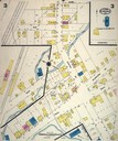
| Date: | 07 1924 |
|---|---|
| Description: | Page 3 of Sanborn-Perris map of Pewaukee. |
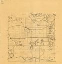
| Date: | 1925 |
|---|---|
| Description: | This map shows township sections, roads, railroads, and lakes. The map also features extensive manuscript annotations noting landownership in pencil. Stamp... |
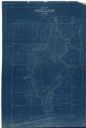
| Date: | 1927 |
|---|---|
| Description: | This blueprint map shows landownership around the lake. Water depths are shown by soundings; relief is shown by hachures. The map was originally created in... |
If you didn't find the material you searched for, our Library Reference Staff can help.
Call our reference desk at 608-264-6535 or email us at: