Filter: Categories of Wisconsin Historical Images
Filter: County of Waukesha
Filter: Year of 1800-1899
Filter: Year of 1880-1889
Filter: Categories of Wisconsin Historical Images
Filter: County of Waukesha
Filter: Year of 1800-1899
Filter: Year of 1880-1889

| Date: | 1885 |
|---|---|
| Description: | Bird's-eye map of Oconomowoc. |

| Date: | 1886 |
|---|---|
| Description: | Bird's-eye map of Menomonee Falls. |

| Date: | 1880 |
|---|---|
| Description: | Bird's-eye map of Waukesha, county seat of Waukesha County. |
| Date: | 1884 |
|---|---|
| Description: | Hawks Tavern, also known as Hawks Inn, with men on the porch and trees in the yard on each side. |

| Date: | 1884 |
|---|---|
| Description: | View of buildings in Delafield, with two men and a dog standing near a fence in the foreground. |
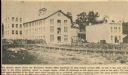
| Date: | 1880 |
|---|---|
| Description: | View of the Waukesha Woolen Mills buildings. Caption reads: "The picture above shows the Waukesha Woolen Mills buildings as they looked around 1880. At lef... |
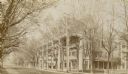
| Date: | 1880 |
|---|---|
| Description: | Side view of Draper Hall on Lake Road. Tree-lined street with two men sitting on chairs in front of Draper Hall. |
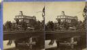
| Date: | 1880 |
|---|---|
| Description: | Stereograph of the Townsend House, a resort hotel. In the foreground there are three people in a rowboat, rowing under a bridge where four other people are... |

| Date: | 1882 |
|---|---|
| Description: | This manuscript map from 1882 shows land use and land for sale in a portion of the Town of Pewaukee, Waukesha County, Wisconsin. Woods, marshland, springs,... |

| Date: | 1887 |
|---|---|
| Description: | This late 19th century map shows the lake region around Oconomowoc in Waukesha County and eastern Jefferson County, Wisconsin. Cities and villages, roads, ... |

| Date: | 03 29 1888 |
|---|---|
| Description: | "Dated this 29th day of March AD 1888." Certifications on verso signed by: William Powrie, county surveyor -- Henry Sherry, landowner -- E.E. Paddock, not... |
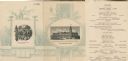
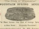
| Date: | 08 01 1889 |
|---|---|
| Description: | Exterior and interior menu listing of the Fountain Spring House, with visitors strolling the grounds of a tree-filled park with the hotel in the background... |
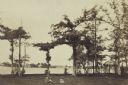
| Date: | 1880 |
|---|---|
| Description: | Lakeside lawn set up for croquet game and garden pavilion at the estate, "Sunnybank." A man sits in the grass with two children. On the right in the backgr... |
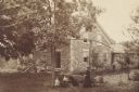
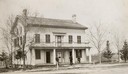
| Date: | 1884 |
|---|---|
| Description: | Exterior of a cobblestone house with women and children in the yard. |
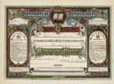
| Date: | 1883 |
|---|---|
| Description: | A colorful certificate that acknowledges the membership of Willie Diederich of Waukesha, Wisconsin into Band of Hope, a temperance organization. |
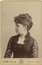
| Date: | 1888 |
|---|---|
| Description: | Waist-up studio portrait of a woman with her head turned to the left in profile. She is wearing a dark-colored lace dress. |
If you didn't find the material you searched for, our Library Reference Staff can help.
Call our reference desk at 608-264-6535 or email us at: