 Filter: Categories of Wisconsin Historical Images
Filter: County of Waukesha
Filter: Type of Map or Atlas
Filter: Categories of Wisconsin Historical Images
Filter: County of Waukesha
Filter: Type of Map or Atlas

| Date: | 1965 |
|---|---|
| Description: | This map shows wards, schools and public buildings, and polling places. The map includes a street index. Lac La Belle, Fowler Lake, and Oconomowoc Lake are... |

| Date: | 1980 |
|---|---|
| Description: | This map shows schools, hotels, stations, roads, railroads, reefs, and public buildings. The upper right corner includes "A Summer and Winter Guide for Spo... |

| Date: | 1859 |
|---|---|
| Description: | This hand-colored map shows township and range in pink, blue, yellow, and orange, land ownership, includes 16 city inset maps showing land ownership, and 5... |
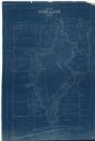
| Date: | 1927 |
|---|---|
| Description: | This blueprint map shows landownership around the lake. Water depths are shown by soundings; relief is shown by hachures. The map was originally created in... |

| Date: | 1950 |
|---|---|
| Description: | This photocopy of a manuscript map shows sectional township grid, hydrography, and acreages as they appeared in 1836. The township lines surveyed by Mullet... |

| Date: | 1934 |
|---|---|
| Description: | This map shows the area as it appeared in 1848 and includes buildings, land use, and roads with distances to nearby locations. The upper right corner reads... |

| Date: | 1941 |
|---|---|
| Description: | This map shows heavy and light industry, residences, and business districts as well as streets and Mill Pond. The front and back of the map include extensi... |
If you didn't find the material you searched for, our Library Reference Staff can help.
Call our reference desk at 608-264-6535 or email us at:

