 Filter: Categories of Wisconsin Historical Images
Filter: County of Waukesha
Filter: Type of Map or Atlas
Filter: Categories of Wisconsin Historical Images
Filter: County of Waukesha
Filter: Type of Map or Atlas

| Date: | 1876 |
|---|---|
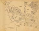
| Description: | This late 19th century map by Increase Lapham shows the lake region around Oconomowoc in Waukesha County and eastern Jefferson County, Wisconsin. Cities an... |

| Date: | 1887 |
|---|---|
| Description: | This late 19th century map shows the lake region around Oconomowoc in Waukesha County and eastern Jefferson County, Wisconsin. Cities and villages, roads, ... |

| Date: | 1930 |
|---|---|
| Description: | This map of Waukesha County, Wisconsin, from the 1930s shows the township and range grid, towns, sections, cities and villages, highways and roads, railroa... |

| Date: | 1896 |
|---|---|
| Description: | Map shows landownership and acreages, roads, and townships. |

| Date: | 1840 |
|---|---|
| Description: | This manuscript map by Increase Lapham shows the railroads, roads, wetlands, lakes and streams, dams, prairies, and settlers in the eastern half of Waukesh... |
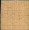
| Date: | |
|---|---|
| Description: | This manuscript map by Increase Lapham shows the lakes and streams in the northwestern quarter of Waukesha County, Wisconsin. |

| Date: | 1911 |
|---|---|
| Description: | This 1911 map from the U.S. Post Office Dept. shows rural delivery routes, active and discontinued post offices, selected rural landowners and houses, chur... |

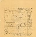
| Date: | 1898 |
|---|---|
| Description: | Map showing the contour depths of the lakes in northwestern Waukesha County, Wisconsin. Roads, railroads, depots, churches, schools, and hotels in the area... |

| Date: | 03 29 1888 |
|---|---|
| Description: | "Dated this 29th day of March AD 1888." Certifications on verso signed by: William Powrie, county surveyor -- Henry Sherry, landowner -- E.E. Paddock, not... |
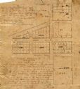
| Date: | 1851 |
|---|---|
| Description: | Ink and pencil on paper. Shows plat of Delafield and local streets. Streets running left to right, top to bottom, are "Main Street 66 feet," "Wells Street ... |

| Date: | 1873 |
|---|---|
| Description: | Plat map of the township of Eagle (T5N, R17E) at a scale of 2 inches to one mile. |

| Date: | 1846 |
|---|---|
| Description: | This map of Prairieville, later renamed Waukesha, is ink and pencil on paper and shows the Fox River, a plat of village, and lot owners. |

| Date: | 1871 |
|---|---|
| Description: | This map of Waukesha shows lot owners, buildings, and various plat additions. The margins of the maps include street reference, a Waukesha business directo... |

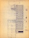
| Date: | 1954 |
|---|---|
| Description: | This map of Waukesha shows numbered ward boundaries, roads, and some buildings. The bottom of the map includes a street index. |

| Date: | 1962 |
|---|---|
| Description: | This map shows the voting districts of Waukesha in red ink for the year 1962. The bottom of the map includes an index of streets. |
| Date: | 1925 |
|---|---|
| Description: | This map shows township sections, roads, railroads, and lakes. The map also features extensive manuscript annotations noting landownership in pencil. Stamp... |
| Date: | 1950 |
|---|---|
| Description: | This map is revised by McMahon Engineering Company, Menasha, Wisconsin and shows plat of town, local streets, concrete monument, iron stake, government sto... |

| Date: | 1965 |
|---|---|
| Description: | This basic street map shows roads, schools, parks and cemeteries and includes a street index in the lower margin. The map also shows a portion of Elm Grove... |
| Date: | |
|---|---|
| Description: | This map is a photocopy and shows the Oconomowoc River, Flower Lake, lot and block numbers and dimensions, additions, streets, C.M.St.P.&P. Ry., T.M.E.R.&L... |

| Date: | 1970 |
|---|---|
| Description: | This map shows lots, house numbers, institutional buildings, and cemeteries. The bottom of the map includes indexes to streets, points of interest and inst... |
If you didn't find the material you searched for, our Library Reference Staff can help.
Call our reference desk at 608-264-6535 or email us at: