Filter: Categories of Wisconsin Historical Images
Filter: County of Washington
Filter: Subject of railroads
Filter: Categories of Wisconsin Historical Images
Filter: County of Washington
Filter: Subject of railroads

| Date: | 1879 |
|---|---|
| Description: | Bird's-eye map of Hartford. |

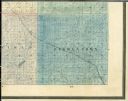
| Date: | 1878 |
|---|---|
| Description: | Bird's-eye map of Kewaskum. Includes a list of hotels, churches, post office, railroad depot, etc. |
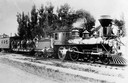
| Date: | 03 29 1933 |
|---|---|
| Description: | "The old wood train." It is a class H3 train built in 1880 by Manchester Locomotive Works. John Rhine, the engineer, is shown. A large group of men are sta... |

| Date: | 1915 |
|---|---|
| Description: | Plat map of Polk township in Washington County. |

| Date: | |
|---|---|
| Description: | Letterhead of the Kewaskum Mutual Fire Insurance Company of Washington County, Wisconsin, with a Native American man wearing buckskin clothes and leggings ... |
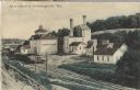
| Date: | 1910 |
|---|---|
| Description: | Postcard of the Stork Brewery facilities. The image includes the brewery buildings along a hillside and railroad tracks in the foreground. There is a sign ... |

| Date: | |
|---|---|
| Description: | Colorized postcard view of the Storck Brewery in Schleisingerville (now Slinger). The brewery buildings are along a hillside, and railroad tracks are in th... |

| Date: | 1859 |
|---|---|
| Description: | This 1859 map of Washington County, Wisconsin, shows the township and range grid, towns, sections, landownership and acreages, cities and villages, roads, ... |

| Date: | 1899 |
|---|---|
| Description: | This 1899 map shows the contour depths of Big Cedar Lake in Washington County, Wisconsin, and includes four cross sections of the lake. Roads, railroads, s... |
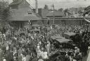
| Date: | 1917 |
|---|---|
| Description: | Elevated view looking down at a large crowd of people gathered at the depot to see off Company D of the 5th Wisconsin Infantry leaving Hartford for Camp Do... |

| Date: | 1878 |
|---|---|
| Description: | This bird’s-eye-view map of Barton is indexed for parochial and public schools, churches, a convent, the railroad depot, and the post office. |

| Date: | |
|---|---|
| Description: | Watercolor reproduction, with key, of the area surrounding Holy Hill (19.) which is at top center, and below are Lake Keesus (J.) and the town of Merton (1... |
If you didn't find the material you searched for, our Library Reference Staff can help.
Call our reference desk at 608-264-6535 or email us at: