 Filter: Categories of Wisconsin Historical Images
Filter: County of Washington
Filter: Subject of human settlements
Filter: Subject of water
Filter: Categories of Wisconsin Historical Images
Filter: County of Washington
Filter: Subject of human settlements
Filter: Subject of water

| Date: | 1879 |
|---|---|
| Description: | Bird's-eye map of Hartford. |

| Date: | 1878 |
|---|---|
| Description: | Bird's-eye map of Kewaskum. Includes a list of hotels, churches, post office, railroad depot, etc. |

| Date: | 1892 |
|---|---|
| Description: | Bird's-eye view of West Bend, looking west. Milwaukee River flows across image just below center, with fairgrounds at bottom right and Maple street at top ... |

| Date: | 1915 |
|---|---|
| Description: | Plat map of Polk township in Washington County. |
| Date: | 1859 |
|---|---|
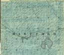
| Description: | Detail of section 5 of the Washington County map showing only Hartford. |

| Date: | 06 12 1998 |
|---|---|
| Description: | "Barth's Linden Inn is located on the West shore of Big Cedar Lake, between Slinger and West Bend on Hwy. 144." From left to right; Ralph "Buddy" Ruecker, ... |
| Date: | 1911 |
|---|---|
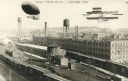
| Description: | Photographic postcard view of the Kissel Motor Car Company. The elevated view shows the factory buildings, water towers, railroad cars and track. A dirigib... |

| Date: | 1859 |
|---|---|
| Description: | This 1859 map of Washington County, Wisconsin, shows the township and range grid, towns, sections, landownership and acreages, cities and villages, roads, ... |

| Date: | 1899 |
|---|---|
| Description: | This 1899 map shows the contour depths of Big Cedar Lake in Washington County, Wisconsin, and includes four cross sections of the lake. Roads, railroads, s... |

| Date: | 1910 |
|---|---|
| Description: | This 1910 map from the U.S. Post Office Dept. shows rural delivery routes, active and discontinued post offices, collection boxes, selected rural landowner... |
| Date: | |
|---|---|
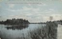
| Description: | Colorized postcard view of the Milwaukee River from the road. There are buildings in the background on the right. Caption reads: "View of Milwaukee River o... |

| Date: | 07 2003 |
|---|---|
| Description: | This Barton dam is the subject of a photo study. Anna Williams acts as a model. |

| Date: | |
|---|---|
| Description: | This map shows land parcels, streets and parks in the city of West Bend. The Milwaukee River is labeled on the left side. |

| Date: | |
|---|---|
| Description: | Elevated view across the Rubicon River towards the factory on the far shoreline. Caption reads: "West Bend Aluminum Co., Hartford Division, Hartford, Wis." |

| Date: | 1911 |
|---|---|
| Description: | Elevated view of the Kissel auto plant in between the railroad and the river. A dirigible and bi-plane have been cut and pasted onto the image. Caption rea... |

| Date: | |
|---|---|
| Description: | A litho-chrome postcard of a dam on the Rubicon River. There is a railroad yard on the far bank. Caption reads: "Old Mill Dam, Hartford, Wis." |

| Date: | |
|---|---|
| Description: | Watercolor reproduction, with key, of the area surrounding Holy Hill (19.) which is at top center, and below are Lake Keesus (J.) and the town of Merton (1... |
If you didn't find the material you searched for, our Library Reference Staff can help.
Call our reference desk at 608-264-6535 or email us at:


