Filter: Categories of Wisconsin Historical Images
Filter: County of Washington
Filter: Subject of church buildings
Filter: Categories of Wisconsin Historical Images
Filter: County of Washington
Filter: Subject of church buildings

| Date: | 1878 |
|---|---|
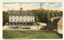
| Description: | Bird's-eye map of Kewaskum. Includes a list of hotels, churches, post office, railroad depot, etc. |
| Date: | |
|---|---|
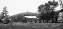
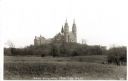
| Description: | View of Holy Hill. Caption reads: "Distant View of Holy Hill, Wis from the South". |
| Date: | |
|---|---|
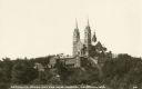
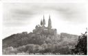
| Description: | View looking up at Holy Hill. Caption reads: "Carmelite Monastery and New Church, Holy Hill, Wis." |
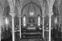
| Date: | 1910 |
|---|---|
| Description: | Interior of Holy Hill, Carmelite Church of Our Lady, Help of Christians. Caption reads: "Interior of Church Holy Hill Wis." |
| Date: | 1910 |
|---|---|
| Description: | View of the steps leading up to the Carmelite Church of Our Lady, Help of Christians. Caption reads: "Steps Leading to Church, Holy Hill, Wis." |
| Date: | 1910 |
|---|---|
| Description: | View of the Carmelite Church of Our Lady, Help of Christians and the nearby grotto. Caption reads: "Grotto of Church, Holy Hill Wis." |
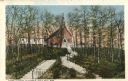
| Date: | 1920 |
|---|---|
| Description: | View of Holy Hill, with a field and the Hillside Hotel in the foreground. Captions read: "America's Favorite Place of Pilgrimage" and "The Holy Hill and Hi... |
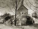
| Date: | 1920 |
|---|---|
| Description: | View of the Carmelite Fathers' home on Holy Hill. Caption reads: "Home of the Carmelite Fathers, Holy Hill, Wis." |
| Date: | 1920 |
|---|---|
| Description: | View of the Carmelite monastery on Holy Hill from the west. Caption reads: "Holy Hill, Wis. From The West." |
| Date: | 1920 |
|---|---|
| Description: | View of the Carmelite monastery on Holy Hill from the north. Caption reads: "View from the North, Holy Hill, Wis." |
| Date: | 1950 |
|---|---|
| Description: | View looking up hill towards the Holy Hill monastery and church. |

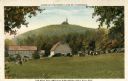
| Date: | 1955 |
|---|---|
| Description: | Elevated view from Holy Hill of the valley below. The roof and side of the church is on the left. |
| Date: | 1963 |
|---|---|
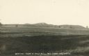
| Description: | Elevated view of the Kettle Moraine area from Holy Hill. |

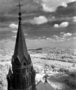
| Date: | 04 04 1949 |
|---|---|
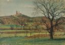
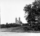
| Description: | Church spires can be seen in the distance above a field and wooded landscape. |
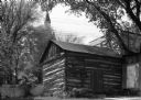
| Date: | 05 24 1961 |
|---|---|
| Description: | Exterior view of an early settler's log cabin. The cabin resides on private property, in downtown West Bend. The steeple of a church is in the background. |

| Date: | 1910 |
|---|---|
| Description: | This 1910 map from the U.S. Post Office Dept. shows rural delivery routes, active and discontinued post offices, collection boxes, selected rural landowner... |

| Date: | 1929 |
|---|---|
| Description: | Map shows townships and sections, landownership and acreages, roads, schools, school districts, churches, and cemeteries. Includes index of acreage tracts. |
If you didn't find the material you searched for, our Library Reference Staff can help.
Call our reference desk at 608-264-6535 or email us at: