Filter: Categories of Wisconsin Historical Images
Filter: County of Washburn
Filter: Categories of Wisconsin Historical Images
Filter: County of Washburn

| Date: | 1941 |
|---|---|
| Description: | This 1941 map covers Washburn County, Wisconsin, as well as western Sawyer, eastern Burnett, and northeastern Polk counties. It shows the locations of tour... |

| Date: | |
|---|---|
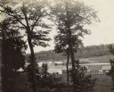
| Description: | Colorized photographic postcard view of a lawn with stone terraces and birch trees leading down to a lake on the left. There is a cabin in the background n... |
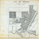
| Date: | 1900 |
|---|---|
| Description: | This map is ink on tracing paper and shows the city of Spooner. The map shows numbered plats, labeled streets, and the Yellow River. |
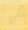
| Date: | 1900 |
|---|---|
| Description: | This map of Minong shows township 42 north platted and area R12 west. The streets are labeled. |
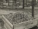
| Date: | 1934 |
|---|---|
| Description: | Box of harvested cranberries at a drying rack. |
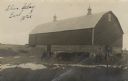
| Date: | 1910 |
|---|---|
| Description: | Black and white photographic postcard of a barn, with two men and cows in the barnyard. There are patches of snow on the ground. |
| Date: | 03 05 2012 |
|---|---|
| Description: | Exterior view of the Garver Feed and Supply Company building, which formerly housed the U.S. Sugar Company. Snow is on the ground. |

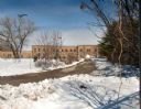
| Date: | 1991 |
|---|---|
| Description: | This map shows public access, fish crib locations, resorts, and other local businesses as well as advertisements for local attractions and a resort index. ... |
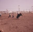
| Date: | 1961 |
|---|---|
| Description: | A crowd of people in the background behind a fence are watching a man bull riding at the Spooner Rodeo. Two rodeo clowns are moving in front of the bull. |
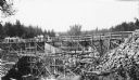
| Date: | 1936 |
|---|---|
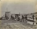
| Description: | Two groups of men are standing on a temporary wooden bridge over the Totogatic River. There is a large form in place on the left and a complete concrete wi... |
| Date: | |
|---|---|
| Description: | Exterior view down slope of several buildings. A sluice gate is partially visible, with several logs nearby. |
| Date: | 1900 |
|---|---|
| Description: | View of several men standing and kneeling in front of mill buildings. There are logs floating near the sluice gate. |
| Date: | |
|---|---|
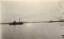
| Description: | View across water towards a tow boat on the lake. Two men are standing on the top of the boat near a chimney spewing smoke. |

| Date: | |
|---|---|
| Description: | View of several bare trees, some of which have nests in them. |

| Date: | 1928 |
|---|---|
| Description: | View of a stick-based structure on water, near a shoreline and forest. Caption identifies it as: "Beaver House on Long Lake." |
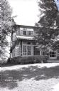
| Date: | |
|---|---|
| Description: | External view along the side of the Kilkare Lodge, which is on a sloping hill. Many of the windows are open. |
| Date: | 1935 |
|---|---|
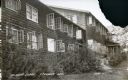
| Description: | External view of Kilkare Lodge. Many of the windows are open. |

| Date: | 1948 |
|---|---|
| Description: | The dining room in Kilkare Lodge on Birch Island Lake. Windows line both sides of the room. Two women are sitting at tables at the far end of the room near... |
If you didn't find the material you searched for, our Library Reference Staff can help.
Call our reference desk at 608-264-6535 or email us at: