 Filter: Categories of Wisconsin Historical Images
Filter: County of Walworth
Filter: Year of 1800-1899
Filter: Subject of transportation
Filter: Year of 1890-1899
Filter: Categories of Wisconsin Historical Images
Filter: County of Walworth
Filter: Year of 1800-1899
Filter: Subject of transportation
Filter: Year of 1890-1899
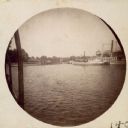
| Date: | 1895 |
|---|---|
| Description: | Elevated view of Lake Geneva with the Lake Geneva steamboat. |
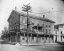
| Date: | 1895 |
|---|---|
| Description: | View from road of the Buena Vista House. There is a utility pole in front with many wires attached. This Greek revival inn was erected in 1843 by Samuel R.... |
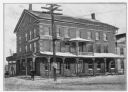
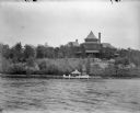
| Date: | 1895 |
|---|---|
| Description: | View of the Buena Vista House with electric power lines. This Greek revival inn was erected in 1843 by Samuel R. Bradley of Milwaukee, who is said to have ... |
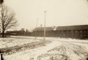
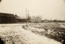
| Date: | 1890 |
|---|---|
| Description: | Esterly Harvesting Machine Company looking southeast across State Street at intersection with Newcomb Street. |
| Date: | 1890 |
|---|---|
| Description: | Esterly Harvesting Machine Company looking southwest across State Street at intersection with Newcomb Street. |
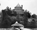
| Date: | 1893 |
|---|---|
| Description: | The rear view of the Ceylon Building, which was from the World's Columbian Exposition in Chicago. The building was later purchased by J.J. Mitchell, moved ... |
| Date: | 1893 |
|---|---|
| Description: | The Ceylon Building from the water, from the Columbian Exposition in Chicago. The building was later purchased by J.J. Mitchell and converted to a private ... |
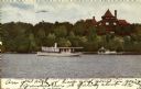
| Date: | 1893 |
|---|---|
| Description: | The Ceylon Building and its pier as seen from Lake Geneva. Originally built for the World's Columbian Exposition in Chicago, the building was later purchas... |

| Date: | 1896 |
|---|---|
| Description: | This late 19th century map of Walworth County, Wisconsin, shows the township and range grid, towns, sections, villages and post offices, roads, railroads, ... |
| Date: | 1898 |
|---|---|
| Description: | This map shows the contour depths of Lake Beulah, Booth Lake, and Army Lake (labeled East Troy Lake on the map) in Walworth County, Wisconsin, and includes... |

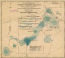
| Date: | 1898 |
|---|---|
| Description: | This map shows the contour depths of Delavan Lake and the Lauderdale Lakes in Walworth County, Wisconsin, and includes nine cross sections of the lakes. Ro... |

| Date: | 1890 |
|---|---|
| Description: | This map shows lot and block numbers and dimensions, landownership, city wards, buildings, streets, railroads, parks, cemeteries, churches, schools, and in... |
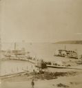
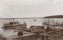
| Date: | 1890 |
|---|---|
| Description: | Elevated view from shoreline of two side wheeled steamboats, the "Lucius Newberry," left, and the "Lady of the Lake," docked at Geneva Lake. Other smaller ... |
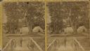
| Date: | 1890 |
|---|---|
| Description: | Stereograph view from footbridge with rustic railings of a small boy wearing a large hat standing at the end of the footbridge. A group of adults and anoth... |
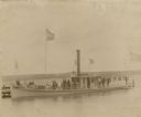
| Date: | 1898 |
|---|---|
| Description: | View across water towards men and women in fine clothes posing on the deck of the steamer Arthur Kaye, which is docked at a pier on Geneva Lake. Nam... |
| Date: | 1895 |
|---|---|
| Description: | View from boat towards the waterfront at Lake Geneva with the Whiting House Hotel on the left and the pier extending to the right. A large sidewheel steamb... |
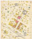
| Date: | 12 1899 |
|---|---|
| Description: | A Sanborn map of Sharon, featuring downtown businesses. |
If you didn't find the material you searched for, our Library Reference Staff can help.
Call our reference desk at 608-264-6535 or email us at: