 Filter: Categories of Wisconsin Historical Images
Filter: County of Walworth
Filter: Year of 1800-1899
Filter: Subject of streets
Filter: Categories of Wisconsin Historical Images
Filter: County of Walworth
Filter: Year of 1800-1899
Filter: Subject of streets

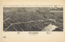
| Date: | 1870 |
|---|---|
| Description: | Bird's-eye view of Whitewater, with insets. |
| Date: | 1895 |
|---|---|
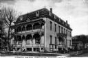
| Description: | View of the Buena Vista House with electric power lines. This Greek revival inn was erected in 1843 by Samuel R. Bradley of Milwaukee, who is said to have ... |
| Date: | 1890 |
|---|---|
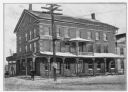
| Description: | Esterly Harvesting Machine Company looking southeast across State Street at intersection with Newcomb Street. |
| Date: | 1890 |
|---|---|
| Description: | Esterly Harvesting Machine Company looking southwest across State Street at intersection with Newcomb Street. |

| Date: | 1873 |
|---|---|
| Description: | Slightly elevated engraved view of the Walworth County Courthouse. In the foreground a man is riding a horse along the street. Pedestrians are on the groun... |
| Date: | 1889 |
|---|---|
| Description: | Veew toward the facade and right side of the Morris Pratt Institute on a street corner. The roof line has an ornate iron railing running around its perimet... |
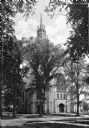
| Date: | 1872 |
|---|---|
| Description: | A view of the facade and side of the First Methodist Church. All visible windows are made of stained glass and the highly ornate steeple is partially obscu... |
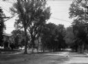
| Date: | 1860 |
|---|---|
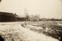
| Description: | A view of a tree-lined residential street with houses partially visible on the left. |
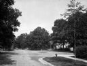
| Date: | 1870 |
|---|---|
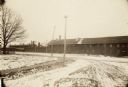
| Description: | A view of an intersection of tree-lined streets in a residential area. Homes are partially visible on the right. |

| Date: | 1870 |
|---|---|
| Description: | A view of a tree-lined residential street, with homes partially visible on the right. |
| Date: | 1884 |
|---|---|
| Description: | This map is a Birdseye view of Delavan, Wisconsin. At the bottom of the map are points of interest that correspond to numbers on the map. Many of the stree... |

| Date: | 1850 |
|---|---|
| Description: | This map of Geneva shows lots and acreages, reserved land, and public squares. Streets and Lake Geneva are labeled. The map includes manuscript annotations... |

| Date: | 1858 |
|---|---|
| Description: | This map is hand-colored and mounted on cloth and shows lot and block numbers and dimensions, landownership, streets, railroads, selected buildings, fair g... |

| Date: | 1882 |
|---|---|
| Description: | This pictorial bird's-eye-view map shows buildings, streets, and railroads. Included are illustrations and an index to points of interest. The bottom of th... |

| Date: | 1890 |
|---|---|
| Description: | This map shows lot and block numbers and dimensions, landownership, city wards, buildings, streets, railroads, parks, cemeteries, churches, schools, and in... |
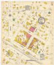
| Date: | 12 1899 |
|---|---|
| Description: | A Sanborn map of Sharon, featuring downtown businesses. |
If you didn't find the material you searched for, our Library Reference Staff can help.
Call our reference desk at 608-264-6535 or email us at: