Filter: Categories of Wisconsin Historical Images
Filter: County of Walworth
Filter: Year of 1800-1899
Filter: Subject of roads
Filter: Categories of Wisconsin Historical Images
Filter: County of Walworth
Filter: Year of 1800-1899
Filter: Subject of roads

| Date: | 1884 |
|---|---|
| Description: | Bird's-eye map of Delavan with inset of the State Institute for Deaf and Dumb. |

| Date: | 1882 |
|---|---|
| Description: | Bird's-eye map of Lake Geneva, looking southwest, with insets of points of interest. |

| Date: | 1870 |
|---|---|
| Description: | Bird's-eye view of Whitewater, with insets. |
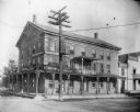
| Date: | 1895 |
|---|---|
| Description: | View from road of the Buena Vista House. There is a utility pole in front with many wires attached. This Greek revival inn was erected in 1843 by Samuel R.... |
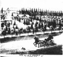
| Date: | 1873 |
|---|---|
| Description: | View of a farmstead with multiple pine trees. A road is in foreground with a carriage driven by two horses, and a man in the carriage. A dog runs in front ... |
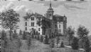
| Date: | 1873 |
|---|---|
| Description: | View of an estate covered with various plants and trees. Two people stand on a sidewalk in front of the distant estate, looking towards it. Two horses dra... |
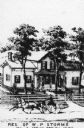
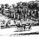
| Date: | 1873 |
|---|---|
| Description: | Engraved view of the W.P. Storms residence, with a horse-drawn wagon in front traveling along the road. Caption reads: "Res. of W.P. Storms Sec 13 Spring P... |
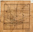
| Date: | 1840 |
|---|---|
| Description: | This 19th century manuscript map shows the roads and proposed routes, villages, and lakes and streams in Walworth County, Wisconsin. |

| Date: | 1896 |
|---|---|
| Description: | This late 19th century map of Walworth County, Wisconsin, shows the township and range grid, towns, sections, villages and post offices, roads, railroads, ... |
| Date: | 1898 |
|---|---|
| Description: | This map shows the contour depths of Lake Beulah, Booth Lake, and Army Lake (labeled East Troy Lake on the map) in Walworth County, Wisconsin, and includes... |

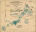
| Date: | 1898 |
|---|---|
| Description: | This map shows the contour depths of Delavan Lake and the Lauderdale Lakes in Walworth County, Wisconsin, and includes nine cross sections of the lakes. Ro... |

| Date: | 1857 |
|---|---|
| Description: | This map shows roads, railroads, lakes, and land ownership by name. Also included are illustrations of select business and residences, business directories... |
If you didn't find the material you searched for, our Library Reference Staff can help.
Call our reference desk at 608-264-6535 or email us at: