 Filter: Categories of Wisconsin Historical Images
Filter: County of Walworth
Filter: Type of Map or Atlas
Filter: Categories of Wisconsin Historical Images
Filter: County of Walworth
Filter: Type of Map or Atlas
| Date: | 1900 |
|---|---|
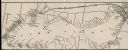
| Description: | A map of Lake Geneva, including the villages of Williams Bay and Fontana, and a portion of the city of Lake Geneva. The Chicago and Northwestern Railway li... |
| Date: | 1930 |
|---|---|
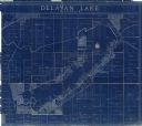
| Description: | This blue line print shows land ownership by name, roads, and highways. The map includes manuscript annotations in pencil. |
| Date: | 1935 |
|---|---|
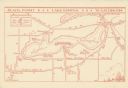
| Description: | This map shows Black Point estate including buildings and signs, as well as a school and store near the village of Linton, country clubs, roads, Yerkes Obs... |

| Date: | 1900 |
|---|---|
| Description: | Map showing a paper city on the shore of Lake Apuckwa (Lake Puckaway) in Marquette or Green Lake County. The map includes certifications signed by John V. ... |

| Date: | 1937 |
|---|---|
| Description: | This cadastral map shows lots, streets, and Pell Lake. The back of the map includes a large advertisement for the Pell Lake Addition summer home lots. |
| Date: | 12 1899 |
|---|---|
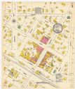
| Description: | A Sanborn map of Sharon, featuring downtown businesses. |

| Date: | |
|---|---|
| Description: | A map of Geneva Village including Geneva Lake. |
If you didn't find the material you searched for, our Library Reference Staff can help.
Call our reference desk at 608-264-6535 or email us at:
