 Filter: Categories of Wisconsin Historical Images
Filter: County of Vilas
Filter: Subject of water
Filter: Categories of Wisconsin Historical Images
Filter: County of Vilas
Filter: Subject of water
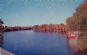
| Date: | 1950 |
|---|---|
| Description: | Elevated view of fall color on Yellow Birch Lake on the Eagle Chain of Lakes. There is a boathouse on shoreline at the right obscured by trees. |
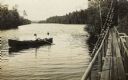
| Date: | 1910 |
|---|---|
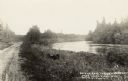
| Description: | View from pier of two boys in a rowboat in the river, east of Eagle River. Caption reads: "Thoroughfare Between Cranberry & Catfish Lakes, Eagle River, Wis... |
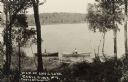
| Date: | 1905 |
|---|---|
| Description: | View looking down hill towards two people in rowboats near the shoreline on Anvil Lake, east of Eagle River, on STH 70. Caption reads: "Anvil Lake, Eagle R... |
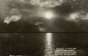
| Date: | 1905 |
|---|---|
| Description: | Moonlight over Everett's Resort on Catfish Lake, east of Eagle River off of STH 70. Caption reads: "Moonlight Over Everett's Resort on Catfish Lake, Eagle ... |
| Date: | 1910 |
|---|---|
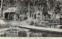
| Description: | View across water towards lakeside cabins among birch trees at the resort on Catfish Lake, east of Eagle River off of STH 70. There is a pier in the foregr... |

| Date: | 1930 |
|---|---|
| Description: | View across water towards Jack O'Lantern Lodge located on Taylor Lake, east of Eagle Lake on STH 70. Caption reads: "Jack O'Lantern Lodge, Eagle River, Wis... |
| Date: | 1930 |
|---|---|
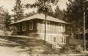
| Description: | View of cottage built into a hill on Taylor Lake east of Eagle River on STH 70. Caption reads: "Guest Cottage at Jack O'Lantern Lodge — Eagle River, Wis." |

| Date: | 1930 |
|---|---|
| Description: | Aerial photographic postcard of Jack O'Lantern Lodge on Taylor Lake east of Eagle River on STH70, including the forest area surrounding the shoreline. Capt... |
| Date: | 1905 |
|---|---|
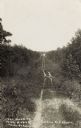
| Description: | The unpaved road along a river on the way to the Red Oak Resort. Caption reads: "On The Road to Red Oaks Resort, Near Eagle River, Wis." |

| Date: | 1920 |
|---|---|
| Description: | View toward a cabin among birch trees at the resort adjacent to the lake, on STH 17 south of Eagle River. Caption reads: "Indian Lake Resort, Eagle River, ... |
| Date: | 1905 |
|---|---|
| Description: | The two-track unpaved road to "The Morey" northeast of Eagle River, on the east side of Otter Lake. Caption reads: "The Road to 'The Morey.'" |

| Date: | 02 1937 |
|---|---|
| Description: | This topographical map of the forest preserve shows highways, roads, trails, telephone lines, Native American reservations, Ranger sub-stations, state nurs... |

| Date: | 1853 |
|---|---|
| Description: | This map shows camps, forts, logging camps, lakes, roads, railroads, the Wisconsin River, and Lac Du Flambeau Indian Reservation. Some points of interest a... |

| Date: | 1910 |
|---|---|
| Description: | This map shows shoreline lot numbers and acreages, the Wisconsin River, and the Michigan and Wisconsin state line. Manuscript annotations relating to topon... |

| Date: | 1911 |
|---|---|
| Description: | This map shows railroads, roads, swamps, a school site and farm, and a mill site. The map includes a "typical township" diagram. Lac du Flambeau, Long Lake... |

| Date: | 1935 |
|---|---|
| Description: | This map shows railroads, telephone lines, roads, trails, schools, sub-agency, lookout stations, churches, community centers, and school site and farm. Bil... |

| Date: | 1962 |
|---|---|
| Description: | This map shows roads, golf courses, ski areas, boat landings, camp sites, waysides, parks, beaches, scenic views, virgin timber tracts, airports, boys and ... |

| Date: | 1955 |
|---|---|
| Description: | This map shows roads, golf courses, airports, fire towers, schools, camp grounds, rivers, streams, lakes, and railroads. The right margin of the map includ... |

| Date: | 1930 |
|---|---|
| Description: | This map shows roads and lakes and includes an inset illustration of Manitowish Waters Fish Hatchery. The back of the map includes a resorts directory, tex... |

| Date: | 1975 |
|---|---|
| Description: | This map shows nature trails, public attractions, public hunting and fishing grounds, dams, waysides, lakes, highways, and roads. The upper right corner in... |
If you didn't find the material you searched for, our Library Reference Staff can help.
Call our reference desk at 608-264-6535 or email us at: