 Filter: Categories of Wisconsin Historical Images
Filter: County of Vilas
Filter: Subject of water
Filter: Subject of industries
Filter: Categories of Wisconsin Historical Images
Filter: County of Vilas
Filter: Subject of water
Filter: Subject of industries

| Date: | 1908 |
|---|---|
| Description: | This 1908 map shows the town and range grid, sections, cities and villages, acreages, settlers, schools, wagon roads, railroads, saw mills, and lakes, stre... |

| Date: | 1953 |
|---|---|
| Description: | This mid 20th century map of Vilas County and northeastern Oneida County, Wisconsin, shows the township and range grid, sections, cities and villages, rail... |
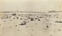
| Date: | 1912 |
|---|---|
| Description: | This view is looking northeast from the site of Norway Springs at the north end of Trout Lake in the spring. In the foreground are tree stumps; in the back... |

| Date: | 1853 |
|---|---|
| Description: | This map shows camps, forts, logging camps, lakes, roads, railroads, the Wisconsin River, and Lac Du Flambeau Indian Reservation. Some points of interest a... |
If you didn't find the material you searched for, our Library Reference Staff can help.
Call our reference desk at 608-264-6535 or email us at: