 Filter: Categories of Wisconsin Historical Images
Filter: County of Vilas
Filter: Subject of transportation
Filter: Year of 1800-1899
Filter: Categories of Wisconsin Historical Images
Filter: County of Vilas
Filter: Subject of transportation
Filter: Year of 1800-1899

| Date: | 1875 |
|---|---|
| Description: | This manuscript map by Increase Lapham, drawn in the last year of his life, shows landownership, roads and railroads, springs, and boat houses around Ocono... |

| Date: | 1853 |
|---|---|
| Description: | This map shows camps, forts, logging camps, lakes, roads, railroads, the Wisconsin River, and Lac Du Flambeau Indian Reservation. Some points of interest a... |
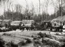
| Date: | 1890 |
|---|---|
| Description: | View across stacks of logs towards a group of men posing near or on a logging train. There are two teams of oxen near the stacked logs, and snow is on the ... |
If you didn't find the material you searched for, our Library Reference Staff can help.
Call our reference desk at 608-264-6535 or email us at: