 Filter: Categories of Wisconsin Historical Images
Filter: County of Vilas
Filter: Subject of transportation
Filter: Categories of Wisconsin Historical Images
Filter: County of Vilas
Filter: Subject of transportation

| Date: | 1950 |
|---|---|
| Description: | Aerial view of the camp, including a numbered index of the buildings. Used as an application form for a forestry workshop. Founded in 1944, located at 519 ... |

| Date: | 1960 |
|---|---|
| Description: | Aerial view of the Trees for Tomorrow Environmental Center, with buildings, grounds, roads, and the Eagle River. Founded in 1944. |

| Date: | 1960 |
|---|---|
| Description: | View across sidewalk and street towards the First Congregational Church, located at the corner of First and Division Streets. Built in 1924. |

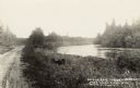
| Date: | 1910 |
|---|---|
| Description: | Elevated view of the Eagle River dock, with excursion boats and a tug boat alongside two long piers in the foreground, and a steel frame bridge in the back... |

| Date: | 1910 |
|---|---|
| Description: | View from shoreline of the Wagon Bridge, which has a steel frame and stone piers. Possibly on Railroad Street. Caption reads: "Wagon Bridge over Eagle Rive... |
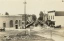
| Date: | 1910 |
|---|---|
| Description: | Slightly elevated view of Wall Street (STH 70). In the foreground is an intersection, with a sign that reads: "Look Out for the Cars." There are storefront... |

| Date: | 1910 |
|---|---|
| Description: | View from pier of two boys in a rowboat in the river, east of Eagle River. Caption reads: "Thoroughfare Between Cranberry & Catfish Lakes, Eagle River, Wis... |
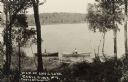
| Date: | 1905 |
|---|---|
| Description: | View looking down hill towards two people in rowboats near the shoreline on Anvil Lake, east of Eagle River, on STH 70. Caption reads: "Anvil Lake, Eagle R... |
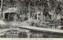
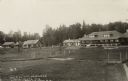
| Date: | 1910 |
|---|---|
| Description: | View across water towards lakeside cabins among birch trees at the resort on Catfish Lake, east of Eagle River off of STH 70. There is a pier in the foregr... |

| Date: | 1930 |
|---|---|
| Description: | View across water towards Jack O'Lantern Lodge located on Taylor Lake, east of Eagle Lake on STH 70. Caption reads: "Jack O'Lantern Lodge, Eagle River, Wis... |
| Date: | 1930 |
|---|---|
| Description: | Jack O'Lantern Lodge on Taylor Lake east of Eagle River on STH 70, showing the Main Lodge. Caption reads: "Jack O'Lantern Lodge, Eagle River, Wis." |

| Date: | 1930 |
|---|---|
| Description: | Aerial photographic postcard of Jack O'Lantern Lodge on Taylor Lake east of Eagle River on STH70, including the forest area surrounding the shoreline. Capt... |
| Date: | 1905 |
|---|---|
| Description: | The unpaved road along a river on the way to the Red Oak Resort. Caption reads: "On The Road to Red Oaks Resort, Near Eagle River, Wis." |
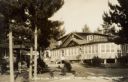
| Date: | 1905 |
|---|---|
| Description: | View across lawn towards main lodge and cabins at the Hemlock Resort on the east shore of Catfish Lake, STH 70, east of Eagle River. Caption reads: "View o... |
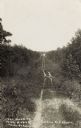
| Date: | 1905 |
|---|---|
| Description: | The two-track unpaved road to "The Morey" northeast of Eagle River, on the east side of Otter Lake. Caption reads: "The Road to 'The Morey.'" |
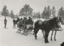
| Date: | |
|---|---|
| Description: | Winter scene with six well-bundled passengers in a sleigh pulled by two horses and pulling two skiers behind. In the background are pine trees. |

| Date: | 02 1937 |
|---|---|
| Description: | This topographical map of the forest preserve shows highways, roads, trails, telephone lines, Native American reservations, Ranger sub-stations, state nurs... |

| Date: | 1853 |
|---|---|
| Description: | This map shows camps, forts, logging camps, lakes, roads, railroads, the Wisconsin River, and Lac Du Flambeau Indian Reservation. Some points of interest a... |

| Date: | 1911 |
|---|---|
| Description: | This map shows railroads, roads, swamps, a school site and farm, and a mill site. The map includes a "typical township" diagram. Lac du Flambeau, Long Lake... |

| Date: | 1935 |
|---|---|
| Description: | This map shows railroads, telephone lines, roads, trails, schools, sub-agency, lookout stations, churches, community centers, and school site and farm. Bil... |
If you didn't find the material you searched for, our Library Reference Staff can help.
Call our reference desk at 608-264-6535 or email us at: