 Filter: Categories of Wisconsin Historical Images
Filter: County of Vilas
Filter: Subject of transportation
Filter: Categories of Wisconsin Historical Images
Filter: County of Vilas
Filter: Subject of transportation
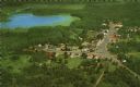
| Date: | 1959 |
|---|---|
| Description: | Color postcard of an aerial view of town. There is a lake in the background in the upper left. |
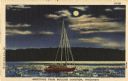
| Date: | 1947 |
|---|---|
| Description: | Colorized postcard of a sailboat in the moonlight. Text below reads: "Greetings From Boulder Junction, Wisconsin." |
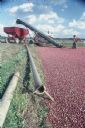
| Date: | 1983 |
|---|---|
| Description: | Cranberry marshes flooded and full of cranberries for the harvest. In the background is farm equipment, and men are removing the cranberries from the marsh... |
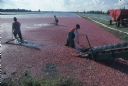
| Date: | 1983 |
|---|---|
| Description: | Men harvest cranberries by raking the fruit across flooded marshes onto a conveyor belt which loads the berries into trucks. |

| Date: | 1931 |
|---|---|
| Description: | View down lake shoreline on Lake Manitowish at Little Bohemia. There are stairs coming down to the lake, and a bench, as well as docks, a flag pole and a d... |
| Date: | 1937 |
|---|---|
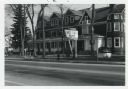
| Description: | View looking down middle of Main Street. Businesses from left to right include the U.S. Post Office, Tire & Battery Service, Store - Tourist & Supplies, St... |
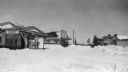
| Date: | 1935 |
|---|---|
| Description: | View looking down a very snowy Main Street. Main Street businesses visible on the left include Tire and Battery Service Marathon Tires. A group of people i... |

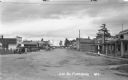
| Date: | 1933 |
|---|---|
| Description: | View of an automobile parked along the side of the road during a scenic drive through virgin forest near Lac du Flambeau. |
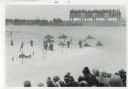
| Date: | 01 1972 |
|---|---|
| Description: | The World Snowmobile Championship showing the track, snowmobiles, competitors, bleachers and spectators. |
| Date: | 01 1972 |
|---|---|
| Description: | Winter scene on Wall Street. Two women cross the street and many cars are parked at the curb. Men appear in the background. Many business signs can be seen... |
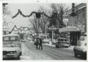
| Date: | 05 1972 |
|---|---|
| Description: | Spring scene on Wall Street. The building is the Arbutus Inn, hotel, bar and dining room. It was also the original Snowmobile Hall of Fame. Two boys are st... |

| Date: | 1926 |
|---|---|
| Description: | This Wisconsin Conservation Commission map from the 1920s shows roads, railroads, campsites, lookout towers, and privately owned lands in Northern Forest S... |

| Date: | 1933 |
|---|---|
| Description: | This 1933 Wisconsin Conservation Dept. map shows roads, railroads, trails, lakes and streams, and the Trout Lake Game Refuge in Northern State Forest (whic... |

| Date: | 1875 |
|---|---|
| Description: | This manuscript map by Increase Lapham, drawn in the last year of his life, shows landownership, roads and railroads, springs, and boat houses around Ocono... |

| Date: | 1908 |
|---|---|
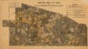
| Description: | This 1908 map shows the town and range grid, sections, cities and villages, acreages, settlers, schools, wagon roads, railroads, saw mills, and lakes, stre... |

| Date: | 1914 |
|---|---|
| Description: | This 1914 map shows the soil types in Vilas County, Wisconsin, and adjoining areas in Oneida, Forest, and Iron counties. Also depicted are the township and... |
| Date: | 1920 |
|---|---|
| Description: | This early 20th century map shows the soil types in Vilas County, Wisconsin, and adjoining areas in Oneida, Forest, Iron, and Price counties. Also depicted... |

| Date: | |
|---|---|
| Description: | This map of Vilas County, Wisconsin, from the first half of the 20th century, shows the township and range grid, towns, sections, cities and villages, road... |

| Date: | 1933 |
|---|---|
| Description: | This mid-20th century map shows the township and range grid, towns, sections, cities and villages, roads, railroads, and lakes and streams in Vilas County,... |

| Date: | 1952 |
|---|---|
| Description: | This Wisconsin Conservation Dept. map shows sections, roads, rivers, and lakes in the Town of Cloverland, Vilas County, Wisconsin as of February, 1952. It ... |
If you didn't find the material you searched for, our Library Reference Staff can help.
Call our reference desk at 608-264-6535 or email us at: