 Filter: Categories of Wisconsin Historical Images
Filter: County of Vilas
Filter: Subject of transportation
Filter: Creator Name of Wisconsin. Conservation Department.
Filter: Categories of Wisconsin Historical Images
Filter: County of Vilas
Filter: Subject of transportation
Filter: Creator Name of Wisconsin. Conservation Department.

| Date: | 1933 |
|---|---|
| Description: | This 1933 Wisconsin Conservation Dept. map shows roads, railroads, trails, lakes and streams, and the Trout Lake Game Refuge in Northern State Forest (whic... |

| Date: | 1952 |
|---|---|
| Description: | This Wisconsin Conservation Dept. map shows sections, roads, rivers, and lakes in the Town of Cloverland, Vilas County, Wisconsin as of February, 1952. It ... |

| Date: | 1952 |
|---|---|
| Description: | This Wisconsin Conservation Dept. map shows sections, roads, rivers, and lakes in the Town of Presque Isle, Vilas County, Wisconsin as of March 1953. It do... |
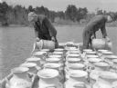
| Date: | 1935 |
|---|---|
| Description: | Two unidentified men, working from a boat or raft, are dumping the contents of milk cans into the waters of a lake. There are small cottages on the shore i... |

| Date: | 1950 |
|---|---|
| Description: | Sunshine brightens autumn oak and maple leaves along a narrow road identified as Razorback Trail. There are also birch and evergreen trees in the woods. |
If you didn't find the material you searched for, our Library Reference Staff can help.
Call our reference desk at 608-264-6535 or email us at: